
It was close, yet still so far away. Boston will not be receiving the all-time snow fall record - yet. Still holding strong at 105.7 inches for the season, we are still in pursuit of the 1.9 inches, which will make it the snowiest winter in Boston. If only this snow was about 50 miles farther north! Next time!
The question is, when will the next time be? The next seven days are looking quiet, and this winter is running out of time as we head toward spring! I am pretty sure we will get there, as there is still plenty of cold left in the pattern, but how frustrating would it be to fall short right at the finish line?!

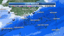
Speaking of frustrating, the snow keeps coming across southeastern Massachusetts, Cape Cod and the Islands. The National Weather Service has expanded the winter storm warning farther into southeastern Massachusetts and Rhode Island through 7 p.m.

Areas in this warning will be seeing six to 10 inches of snow. Roads have become very slippery and snow-covered. It is a very heavy, wet snow that is sticking to everything. Schools and businesses have been let out early, and there is a general mad scramble navigating the roads just to be safe in the snow.
Please use caution, as we are getting numerous reports of spinout and accidents.


This moisture is riding along a stalled front parked off the coast. It will continue to snow along the south coast this afternoon right into the evening hours for the Cape and Islands, and gradually diminish. It will take the Cape and Islands until midnight for the snow finally to end.
Dry, colder air is moving into New England for the evening hours with clearing skies. Lows will drop into the single digits. Watch for the beautiful full worm moon to illuminate the evening sky.
More Snow? Winter Weather Blankets DC
Temperatures will be cold for the next 24 hours with building high pressure. A cooler-than-normal airmass will remain for the weekend. Overall, it looks like a fairly quiet stretch of weather that will lead us into next week as temperatures will begin to moderate into the lower to mid 40s by Wednesday.
Another sign of spring - daylight saving time begins this weekend! We spring ahead one hour at 2 a.m. Sunday. The sun will set Sunday at 6:45 p.m.
