
Temperatures are a little bit lower today thanks to a push of air from southeastern Canada. There's not a lot of wind, but it is coming from the northeast so temperatures at beaches will be in the lower 70s while inland it's closer to 80°. There's plenty of sunshine, but a few fair weather clouds are around, with a slight chance for a sprinkle or shower.
Mostly clear tonight with a bright moon and comfortably cool once again, late night temperatures in the 40s north to 50s south.
For parts of Northern Maine it could be cold enough for a bit of frost.
High-pressure overhead rules are weather this weekend, with plenty of sunshine and temperatures going back up into the 80s, but still a bit cooler at the coast. Great weather for the lakes and mountains, and the seashore, the sunburn factor close to a 10 out of 10.
Humidity remains low enough, that each night should cool off back to the 50s and 60s.
The air becomes more humid for Monday and Tuesday, with high temperatures close to 90° and a threat for thunderstorms on Tuesday afternoon.
The second half of next week looks partly sunny with a few showers and temperatures close to 80°
Local


From the interesting meteorology department: A storm at sea this weekend was a bit of an issue for our Father's Day forecast.
Here is an interesting comparison from one of our weather forecast computer models.
The model, ECMWF (European Centre for Medium-Range Weather Forecasts), better known as 'The Euro' had threatened us with a Father's Day Nor'easter.
Here's what the 7-day forecast for Father's Day looked like from back on Sunday (June 12th). If this verified we would have cold, wet and windy along the south coast.
Now here is what 'The Euro' shows for Father's Day.
A huge difference, the storm is weaker and 100's of miles farther away.
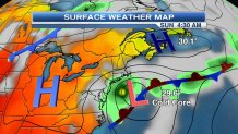
High pressure generally means fair weather, due to sinking air. Sinking air generally warms and dries due to compression.
Low pressure generally means clouds and precipitation, due to rising air. Rising air generally cools and condenses due to expansion.
The fact this weekend has such a strong high, originating in Canada, means plenty of sunshine and warm days and comfortably cool nights.
Often we talk about Bermuda High Pressure during summer, that would be warm and humid.
But this weekend we get Bermuda Low Pressure, and Canadian High Pressure, a real treat. We save energy (and money) by not having to power up air conditioning units.
The summer solstice is Monday, the first calendar day of summer, it's fitting that we will start to have more humidity then as high pressure moves to our south, allowing for more of a flow from the south. Wind is air moving from high to low pressure. So when the high is south of New England, the air comes across warmer waters of the gulf stream, and humidity goes up. We could use some rain, and a front from Canada moves in Tuesday with a round of thunderstorms. Not everyone gets wet, but some areas could see an inch of rain in the more intense storms. The threat for damaging wind with Tuesday storms is on the high side.
The next big weather question is what happens to the Tuesday front, if it goes out to sea, we get drier weather later next week. If it stalls along the south coast we may have some more rain on Wednesday or Thursday. At this point odds favor the front moving off enough for more dry than wet, with near seasonable temperatures.
