
Most of our Thursday is dry in New England. We are tracking a front in northern Maine where a few showers are possible in the afternoon.
Also low pressure over Pennsylvania may bring some rain to Connecticut late in the day.
Otherwise the sky is mostly cloudy, with highs near 70. Wind is from the southwest 10-15 mph.
A storm is developing over the ocean south of New England overnight. The south coast from Connecticut to Cape Cod will have a period of rain. The rest of New England is dry with overnight lows near 50.
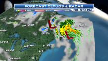
Rain ends on Cape Cod early as the ocean storm intensifies and race into the Canadian Maritime Provinces. Another cold front from southeast Canada will race across New England Friday afternoon, merging with the Maritimes storm. That means a few showers or a thunderstorm Friday, but most of the day is dry, with highs near 70. Wind shifting and increasing from the northwest late in the day.
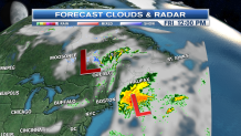
Another batch of cold air is here early Saturday with a possible late season freeze. As the front merges of the Canadian low, we may have a bit of snow in the mountains of New Hampshire and Maine Friday night and early Saturday. Low temperatures in the 20s and 30s will be close to record cold.
Local


For most of us though, Saturday features a mix of sunshine and fair weather clouds, highs 55 to 65 north to south, wind from the northwest 20-25 mph. High pressure passes south of New England Saturday night, with mostly clear skies and lows again in the 20s and 30s in the colder valleys, 40s elsewhere.
[[304567551 , C]]
Sunday is the possible beach day. Wind will shift and come in from the west and southwest Sunday with sunshine and temperatures back up into the 70s. A few showers are possible in the northern mountains.
A warm front brings in clouds and showers Monday, highs near 70.
