
High pressure from Canada has brought in cold dry weather for tonight, and most of tomorrow.
Overnight low temperature in the single numbers in teens north, two teens and 20s south.
Sunshine will fade behind increasing high clouds tomorrow, with high temperature in the 30s to near 40° south, 20s north.
The storm that's been producing ice and snow in the middle of the nation arrives in New England Tuesday. With fair skies early Tuesday, temperature start off in the teens and 20s once again, climbing to the 30s under thickening clouds.
By afternoon a mix of rain, sleet, and snow arrives in Western New England.
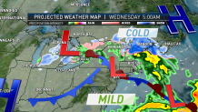
Primary low pressure tracks into upstate New York Tuesday night, but there will be a redeveloping low-pressure system near Long Island Wednesday morning.
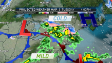
This sets up the possibility of wind from the east and cold air getting stuck in part of New England, setting up a prolonged snow and ice event in northern New England.
Local


For most of southern New England especially Boston west to Springfield, we should have primarily a cold rain most of Wednesday.
But from north of the Massachusetts Turnpike, especially along Route 2 in northern Massachusetts, it will be cold enough that snow and ice may linger for a few hours Wednesday morning.
Most of the ski areas in Vermont, New Hampshire, and Maine, should see all snow Tuesday night and Wednesday, perhaps lingering right into Thursday.
Snowfall amounts of 5 to 10 inches are likely in the hills of Central and Northern New England, with greater amounts of the highest elevations. Rainfall of 1/2 to 1 1/2 inches possible central and south.
High temperatures each day in the 30s to lower 40s.
Drier weather will arrive on Friday, with slightly warmer air, high temperature in the 40s.
The weekend outlook is challenging, as we should warm up, but there may be a persistent flow from off the ocean keeping some of eastern New England cool, and perhaps gray.
We will be fine tuning as the week goes on.
