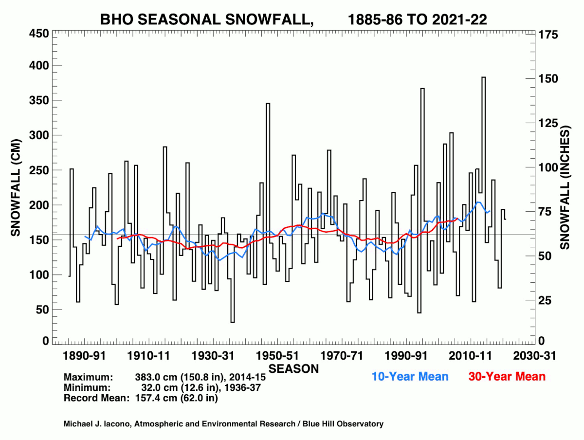
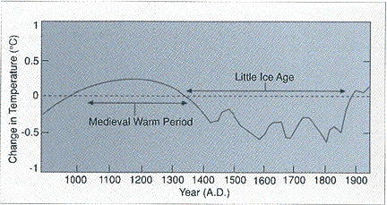
In his Daily Discussion, Meteorologist Sean Fankhauser at Blue Hill Observatory, reports that the weather station in Milton Massachusetts is running 5.6 degrees above normal per day this month of January. That is about the same as October, November, and December. And snowfall for the season is 16.5" or about 10.6" below the climatological average. What's going on? Weather is like a pendulum, constantly moving back and forth from one extreme to another. The last twenty years have been very snow at Blue Hill, while the temperature on Blue Hilllittle Ice Age late in the 19th century. Weather cycles range in periods from hours, to days, to weeks, months, years, centuries, millenea, and so on. For example, much of this winter we have seen cold dry air arrive on Sunday only to be replaced by warmth by Wednesday and Thursday. It seems we have had wind damage in ehe Weds/Fri period nearly every week since October. Thomas Prindle at Wildcat Ski Resort in New Hampshire points out that it has snowed every Thursday so far this year. Predicting all the different cycles on the weather maps is nearly impossible, but we keep trying. This winter has been especially difficult. Why? I don't know. The end. (kidding) Perhaps the challenge of this winter has to do with the huge extreme ranging from what's happening in Alaska and the Arctic, compared to the lower 48 of the United States. We know how warm we are, do you know how cold Alaska is. This image from the Fairbanks Alaska Web Cam January 29, 2012 shows the frozen air.
has been on a continuous warming trend since the end of
Here in Fairbanks the temperature cooled to -50 degrees Fahrenheit both January 28 & 29 2012, the first back to back -50 since December 1999. January 2012 is one of the coldest months on record in central Alaska. Snowfall amounts are also setting records in Alaska this winter. If we add Alaska and New England, then divide by two we get 'Normal' weather.. A Balance of the extremes. But the fact that this chill exists in Alaska, we have to be on guard for an Extreme Arctic Attack here in New England right through the Spring Equinox. Even a little release of this arctic chills sets up potential wintry weather blasts at least once a week for us. A Little upper level spin is producing thunder snow in the Northeast tonight, this 'minor' event is a tiny example of what can happen. With such extremes in no wonder we have had so much wind. Tonight, will mark the 3rd night in a row of wind gusts past 45 mph, maybe even a bit of thunder snow. Cold dry air is here for Monday. Then the boundary separating our brief cold spell, and more spring like warmth will bring an inch or two of snow for Tuesday. A wave of low pressure of Pacific origin is racing across Canada, and will cross Maine Wednesday with snow and cold for Ontario, Quebec and northern Maine, even as the temperature pushes 60 in Boston. A weak cold fron pushes to our south on Groundhog Day. Then we watch a series of Paicific origin storms tarck south of New England Friday and over the weekend. Any one of these storms has potential to bring rain and snow February 3 and on. This is the anniversary of The Blizzard of 1978, a very high stakes time period for Nor'easter's. The stage is set for an extreme event, given the extreme temperature gradient in North America this winter. It will be surprising of we make it through February 2012 without enduring a major to severe Nor'easter. Until then, we ride the wave of a mostly mild winter. When the temperature reaches 60 I have no problem surfing instead of skiing, as was the case here on Massachusetts Bay this past Monday. But I am more inclined to think we will be seeing deep snow in our mountains the next two months.


