


Wednesday: Hot and humid. Partly cloudy with a spot shower north. Highs around 90. Wednesday Night: Partly cloudy and muggy. Lows in the 60s and 70s. Thursday: More clouds, scattered showers and storms. Very humid. Highs in the 80s.
Some of the record heat that has been impacting much of the nation the last few weeks is spreading into New England. However it is not record warm here, or even as warm as last Wednesday, but many spots do warm to near 90 today, and through the weekend.
A strong storm system is crosses northern Quebec, a series of trailing cold fronts will push into Western New England each afternoon the next few days.


The fronts are running out of energy as they cross New England so the heaviest weather is mostly off to our west and north.
For today we have partly to mostly sunny skies with warm to hot temperatures in the 80s to low 90s, just a slight chance of a shower or thunderstorm late in the day.
Wind from the south-southwest increasing 15 to 20 mph during the afternoon, as humidity levels go up with the dewpoint in the 60s.
Warm and muggy overnight tonight, with a low temperature in the 60s to near 70.
Local


Tomorrow is a bit more humid with temperatures once again near 90, and a better chance for thunderstorms during the afternoon.
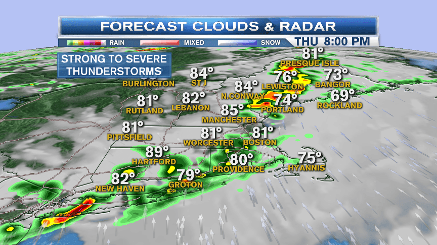
The map for 4:30 PM shows a line of thunderstorms near the Connecticut River, some of these thunderstorms will contain wind gusts past 55 mph that will cause localized damage.


The line of storms, shown in red and orange on the map, will be moving from west to east in about 25 to 30 mph and will weaken rapidly as they reach our eastern shores and the Boston area around 8 PM.

Friday will feature similar warmth, without slightly less chance for the shower or thunderstorm.
This weekend we still have a front around, but it should get just for enough away to leave us more sun and clouds, a chance of a shower or thunderstorm Saturday, high temperatures in the 80s, slightly lower humidity.
Sunday looks mostly sunny with moderate humidity, and a high temperature in the 80s once again.


