


Sunday: Coastal snow showers to start, with system snow (rain along the Cape) ramping up by the afternoon from SW to NE. Highs in the low to mid 30s. Sunday Night: Heaviest snow moves in this evening and continues through the overnight. Winds pick up with overnight lows into the low to mid 20s.
Yesterday the temperature in Oklahoma hit 100 degrees, all time heat for February. At the same time in eastern Canada the temperature was close to 40 below zero.
This extreme thermal gradient is the boundary on which we are watching our next potential blizzard evolve.
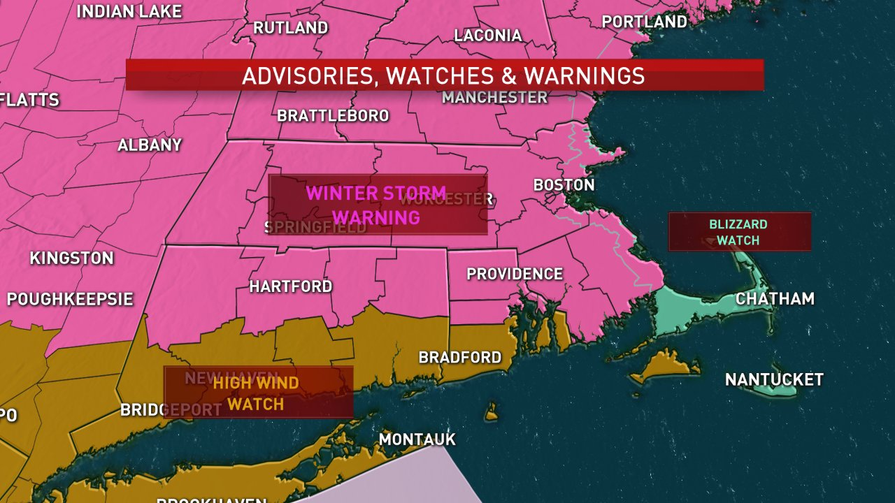
Winter storm warnings are up for most of New England, a blizzard warning southeastern Maine, and a blizzard watch on Cape Cod for tomorrow.
Snow arrived in both eastern New England and southwestern New England early this morning, and is now coming at us from both directions.
By sunset we are all in the snow except for eastern Maine, roads will be very bad from late afternoon right through much of tomorrow for eastern New England.
Low pressure over upstate New York is redeveloping south of Long Island, passing very close to Cape Cod, and slowing down, and intensifying rapidly during the day tomorrow.
Difficult to predict their exact timing and position, but bands of heavy snow will rotate around the backside of the storm tomorrow impacting most of central and southern Maine, the seacoast of New Hampshire, and eastern most Massachusetts, especially Cape Cod in the islands.
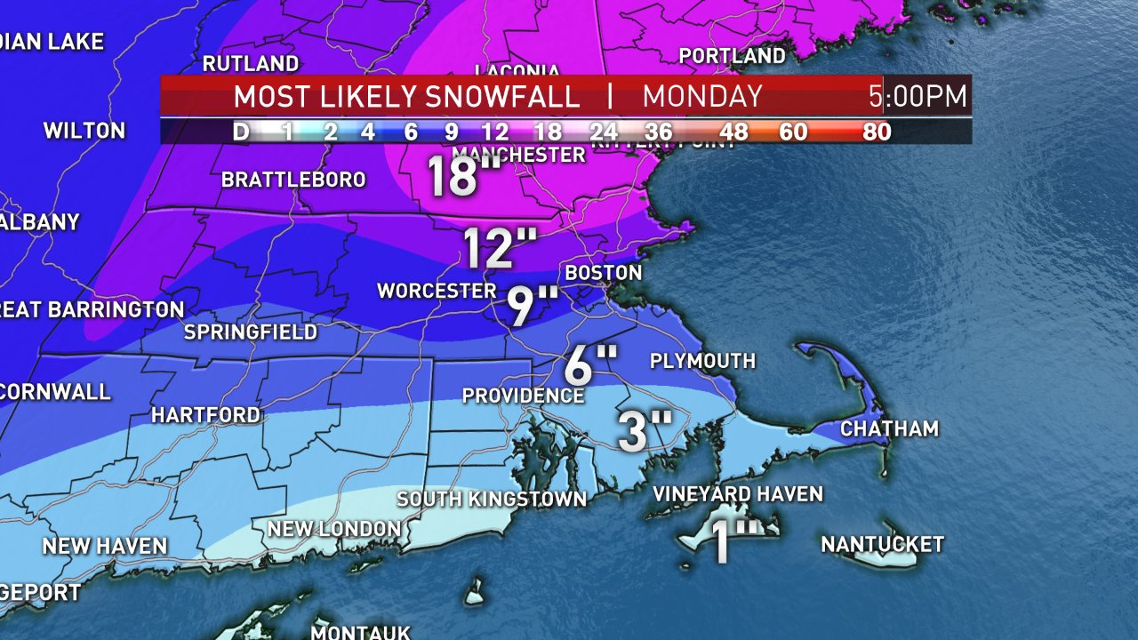
Unlike the Thursday storm, where the heaviest snow was in Connecticut Central Massachusetts, and southern New Hampshire, this time the heaviest snow is in eastern New Hampshire and Maine, and perhaps parts of northeastern Massachusetts.
The worst of the storm is pretty much done in Western New England late tonight, with a little lull possible in southeastern New England during the early morning.
But mid-morning tomorrow as the storm gets stronger, we will see heavy bands of snow right along the coast that may create blizzard conditions from roughly 10 a.m. to 2 p.m. near Boston and Cape Cod. In Maine, the worst is all day tomorrow.

Any rain near the coast today, changes over to snow tonight and continues tomorrow.
Temperatures for the most part holding in the 20s, except 30s along the coast before falling back. Wind from the northwest for most of New England gusting 30 to 45 miles per hour later this evening and through tomorrow.
At the coast line winds may gust close to hurricane force, there is a hurricane wind warning in effect out to Sea for this storm.
U.S. & World


We are just passed a full cold moon, and tides are running strong. High tide at noon time tomorrow will be the most impact. Waves of 15 to 25 feet, combined with winds gusting past 50 mph will create the threat for moderate coastal flooding, and major erosion. Tide heights near Scituate and Boston may exceed 13 feet.
Snow will end in eastern Massachusetts late in the day tomorrow, but continue in the state of Maine through midnight or so.
Snowfall totals averaging about 10 inches for most of New England, similar to the last storm. But in areas where is snow for longer time, especially parts of eastern Massachusetts north of Boston, the New Hampshire seacoast, and much of central and southern Maine we expect 15 to 20 inches of snow, perhaps a little bit more toward the Maine mid-coast.
Valentine's Day Tuesday we get a little break, with some sunshine and temperatures generally in the 20s in the wind diminishing.
A piece of energy coming from Canada crosses New England Wednesday and early Thursday.
At this time it does not look like a huge storm for southern New England, but maybe significant again in the state of Maine.
It's more of a snow squall the type situation off and on Wednesday, with a burst of heavy snow in Maine and New Hampshire Wednesday night.
The early outlook on accumulations is a few inches south and west, to more than a foot and parts of Maine.
It looks cold and windy for the balance of Thursday, and to Friday. Then we may actually see a warming trend.
In the early call for next weekend is for sun and clouds, with a few mixed showers possible Saturday as temperatures warm back to the 40s for the weekend.


