


Today (Wednesday): Calm before the storm. Partly cloudy with highs in the 20s. Overnight Wednesday Night: Clouds increasing with snow south late. Lows in the 20s. Thursday: Heavy snow, damaging winds and coastal flooding. Blizzard conditions across South Coast. Highs in the 20s.
You may have noticed on your daily scroll through your Twitter or Facebook feed the hashtag #BombCyclone mentioned by someone you follow or trending on social media.
The hashtag is referring to the system that has spawned snow showers for northern Florida, southern Georgia, and will continue to slide up the eastern seaboard into our neck of the woods by Thursday morning’s commute.
As this system approaches southern New England, it strengthens over the relatively warm coastal waters. The hashtag “Bomb Cyclone” is a play on words with the phenomenon in the meteorological field, “Bombogenesis.”
Bombogenesis is a rapidly intensifying cyclone that drops in surface pressure by 24 or more millibars in a 24-hour period. Lines of equal surface pressure, also known as isobars, are the black lines surrounding the low-pressure on the accompanying image.

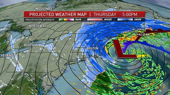
When these lines are tightly packed on a surface weather map, that means strong winds. When they are far apart, that means relatively calm winds. In this case, with the rapid intensification, these isobars will continue to increase in frequency as the storm gets stronger. This is timely, as bombogenesis typically occurs between October to March with large temperature differences sweeping across the country or even the differences between a cold air mass and a warmer ocean.
U.S. & World


Since we have been under a very cold air mass over the last several days, and with the low-pressure system hugging the eastern seaboard entering our open ocean waters just off the coastline of New England, which are still maintaining 40 degree range, that’s enough to create a temperature difference between the water and the air mass, enough to strengthen the system in less than 24 hours.
By late Wednesday night, the central pressure of the storm will be 996 mb, and by Thursday night, the central pressure will have dropped to 960 mb, a difference of 36 mb in a little less than 24-hours.
With the rapid intensification, think of a figure skater on the ice. When the figure skater puts their arms out, they do not spin as fast, but when they bring their arms closer together, they can spin much faster.
With the rapid intensification and deepening pressure, the wind whips around the system even faster. For this potent storm, gusts could reach 50 to 60-plus mph along the southern coast. Not only that, but the heavy snow bands will increase in intensity over the course of the day Thursday, with blizzard conditions ramping up from 9 a.m. to 5 p.m.
Be sure to stay tuned to the very latest details on this storm on air, online and on our NBC 10 Boston/necn app.


