
Weather Forecast: Big Nor'easter to Impact New England
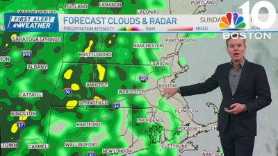
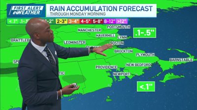
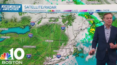
A large coastal storm will track through New England Tuesday through early Thursday with torrential rain, gusty east- northeast winds, heavy mountain snow, and sleet, freezing rain for some. Minor coastal flooding along the east Massachusetts coast line is also possible. Storm is just starting to get organized, an upper level low currently over the Great Lakes will dive southeast & scoop up a coastal storm currently over the Carolinas, steering the center of the storm right towards New England. The current track will keep most of coastal Maine, central & southern New England in the “warm sector”; however, in central New England there will be a period of a wintry mix before the change-over to rain. Strong east-northeast will be an issue, especially along the immediate coast. Coastal Essex county, coastal Plymouth county and The Cape & Islands are under a High Wind Watch due to the possibility of wind gusts up to 60 mph. I think the strongest winds will be between 1pm-and 7pm tomorrow. A widespread 2″-3″ inches of rain is expected across southern New England, coastal New Hampshire and coastal Maine. There could also be localized higher amounts of 4″ of rain. Urban & poor drainage flooding is a concern in these areas. The storm will not intensify rapidly (what we call bomb genesis) but it will stall out over New England and continue to wrap around moisture from the Atlantic as it slowly pulls away Wednesday night into Thursday morning. Green Mountains, the northern tier of the White Mountains and Northern Maine will see a foot or more of heavy, wet snow. We will have to watch places like Bangor & Augusta who will have marginal temperatures & it will be a battle between snow & rain throughout the day tomorrow.