
A showery Friday has seen the bulk of the showers focused in the morning hours, though a few, occasional showers will continue passing though our New England skies during the remainder of the day.
A brief period of southerly winds able to bump temperatures into the 50s and even a few 60s south of the Massachusetts Turnpike is giving way to a northerly breeze, carrying the rest of New England’s cool air southward on gusts as high as 35 mph for Cape Cod.

This new flow of cooler air is also drier by nature and will lead to gradual overnight clearing Friday night after some mixed snow and rain showers in Northern Vermont, as temperatures settle into the 30s by dawn Saturday for most of New England.
Get New England news, weather forecasts and entertainment stories to your inbox. Sign up for NECN newsletters.
A fair Saturday sky will deliver a great day, overall, with high temperatures in the 50s for Central and Southern New England and little more than a midday to afternoon sprinkle from bubbling, puffy, fair-weather clouds – while Northern New England finds more in the way of clouds with a few passing snow and rain showers at times in the mountains and scattered, quick afternoon showers in Maine.
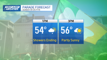
Our next weather-maker arrives for St. Patrick’s Day and while the storm center isn’t strong and will pass north of New England, across Quebec, a round of rain showers – mixed with snow in the mountains – will cross New England from west to east Sunday morning to midday.
Local


After midday, any showers become far more scattered with breaks of sun emerging and an increasing westerly wind gusting to 30 mph at times, meaning South Boston’s parade and the others around New England Sunday afternoon likely see mostly dry hours with just a passing shower at times.
One worthwhile note is a daylight milestone Sunday – St. Paddy’s Day marks the return of 12+ hour daylight for the first time since Sept. 25!
Next week surely looks cooler than this week was, with most days near or cooler than the seasonal normal high temperature of middle to upper 40s, but that cool air should keep us relatively dry on most days.
One midweek disturbance may deliver scattered showers, then next weekend a storm developing south of New England will need to be watched for a chance of rain…or snow, depending on how much cool air from the week can hold on.
Our First Alert Team will keep you posted!
