
Not the nicest of travel days Tuesday. Snow, mix, rain will all be part of the picture during this daylong event.
First up is the light snow Tuesday morning. As we close in on noontime, above-freezing air will move in along the coast (and aloft), switching most to rain from Boston south. On the North Shore, and throughout Metrowest, cold will remain intrenched, so we're expecting icing to be the issue.
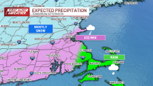
Some light glaze is possible, especially along the Interstate 128 belt in the afternoon. Road treatment will likely take care of it, but untreated surfaces will be slippery.
Get New England news, weather forecasts and entertainment stories to your inbox. Sign up for NECN newsletters.
Elsewhere to the northwest, we’ll be deeper into the cold air along the I-495 belt and into southern New Hampshire. This will keep the snow piling up right until the end of the storm.
Where we stay all snow, the amounts should be in the 3 to 6 inches range. Otherwise, with a change to ice and rain, the amounts will tail off — or in the case of that "Up to 1" on the map above, be washed away.

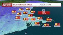
As the storm departs, the cold rushes back in. Temperatures will quickly drop back to the 20s in the spots that rose above freezing. Beware of slippery walkways, parking lots, and driveways into Wednesday morning. Speaking of, the Sun returns to stay throughout the day and into Thursday. Under cold high pressure, we barely move the needle.
Highs will stay at or below freezing through the end of the week.
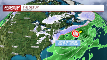
We're eying another storm late Friday that takes a swipe at us from offshore. It's a large system, so we're giving it a wide berth.
Even a close brush could give us some accumulation. We’ll keep you informed online, on-air and on your favorite streaming platform.
Safe traveling!
