Despite the quiet in the coming days, our focus is shifting to the weekend storm. In a winter that hasn't seen much snow (and factoring in the almost snowless winter last year), this storm has everyone by the tail.
Model forecasts, which we have used since the dawn of forecasting, are now freely exchanged and debated on social media. Opinions and dissections of the forecast are offered by anyone who wants to jump in the fray. And there are the apps, which parrot the weather models snowfall forecast, spitting out a bald-faced number lacking critical details.

Sadly, a lot of those numbers are flawed. Not because weather models are bad in of themselves, but because they're bad at estimating snow. Like really bad.
Get New England news, weather forecasts and entertainment stories to your inbox. Sign up for NECN newsletters.
It helps to make sense of it all with some boundaries. First off, this is not a blockbuster storm. Second, it's not really a nor'easter either (wind direction — the biggest moniker for determining a nor'easter) is from the east, not northeast. Lastly, I'm still smarting from the lessons learned last winter, where we saw mix and rain and waited (and waited) for the changeover to snow that sometimes never came.

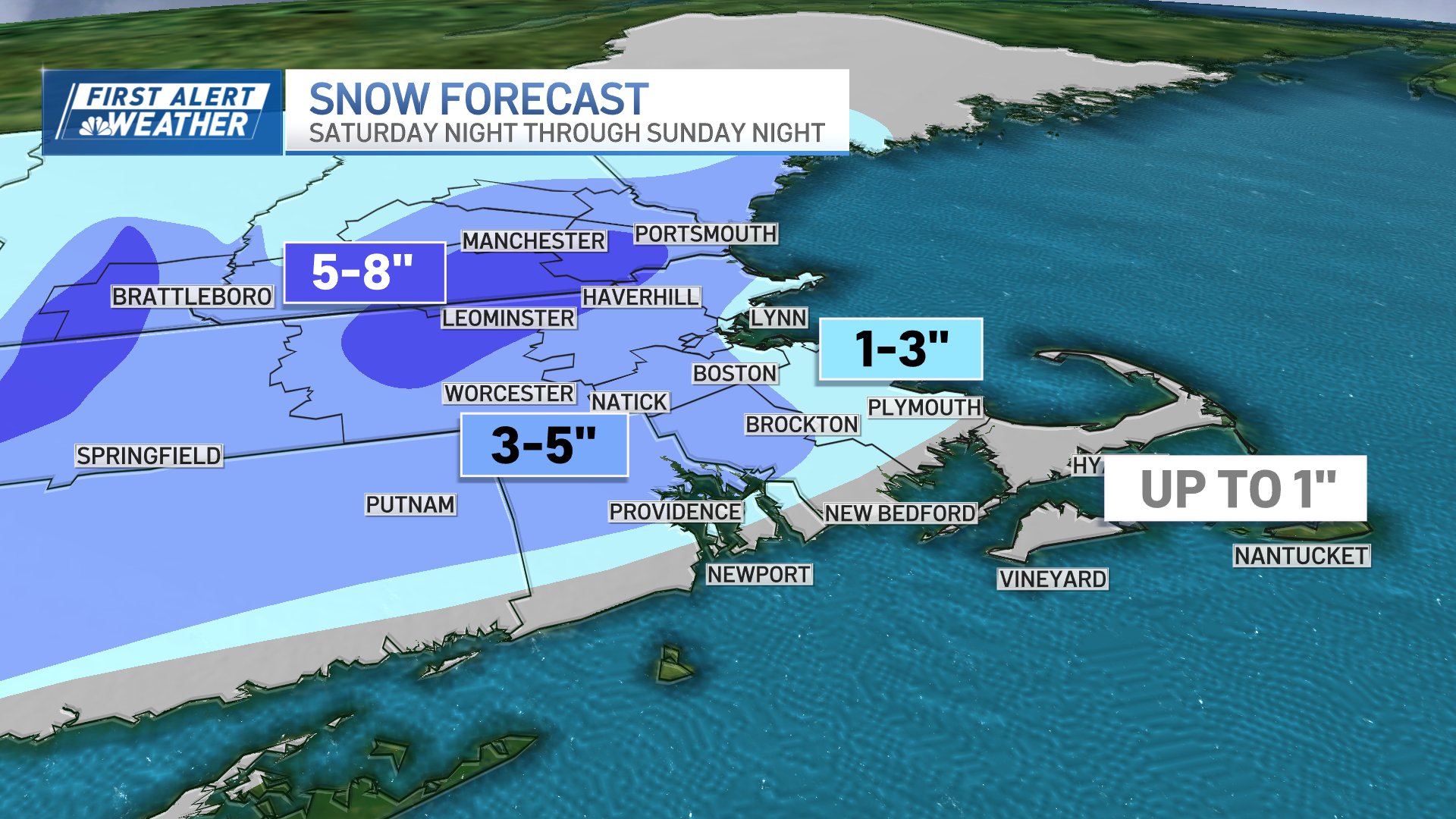
How much snow will Massachusetts get this weekend?
And that's the issue here. Again. Temperatures will allow for some to stay all snow (looking at you, north and west of Interstate 495), while we battle through the wet snow/rain mix elsewhere at the start of the storm. As cold air is drawn in, we'll turn to snow during the late morning and early afternoon on Sunday, but at that point, how much time will be left for the snow to pile up? Therein lies the issue.
We're thinking there will be enough to accumulate 1 to 3 inches along the coast, and 3 to 5 inches inland. Higher amounts of 5 to 8 inches are likely north of Worcester arcing up into southern New Hampshire, where the colder air will be present before, during and after the storm.

Sunday winter storm impacts
With the drop in temperatures comes the tricky travel on Sunday afternoon. Any slushy, untreated roads, driveways, sidewalks will freeze or ice up. With plenty of travel and treatment on the main roads, we should be in decent shape.
Always wise to be safe anyway, given that we haven't seen much snow this season.

Winds along the Cape and the Islands will gust over 40 miles per hour during Sunday afternoon as the storm pulls away. Quite cold Sunday night into Monday morning as we fall into the teens and low 20s.
More storms next week?
Next up, some wind and rain for Tuesday night and Wednesday. And still another storm looming late next week. Yay.