
-

UAE government unit denies cloud seeding took place before Dubai floods
The NCM said it had tracked the incoming heavy rainfall but did not target any clouds during that period, attributing the storm to natural rainfall.
-

When is the first day of spring 2024? What to know about the vernal equinox
The vernal equinox marks the start of the spring season for the Northern Hemisphere. Here’s what to know about how we split up the year using the Earth’s orbit.
-
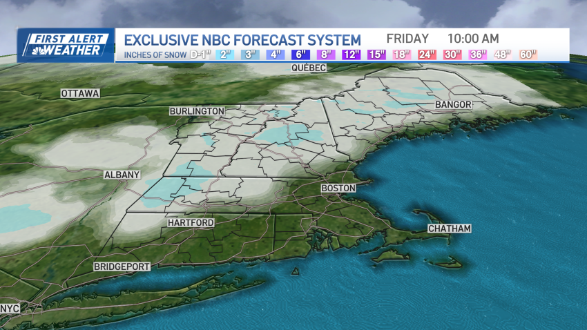
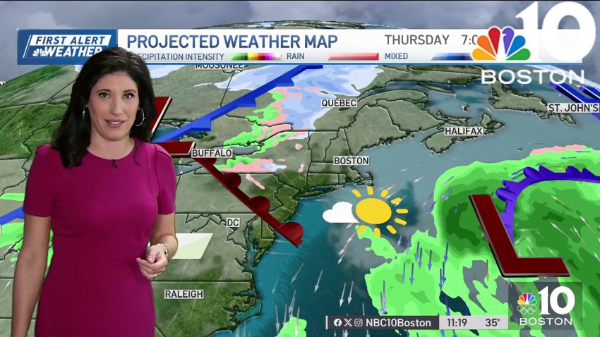
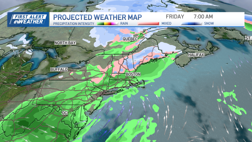
Snow possible for parts of northern New England overnight
As the center of high pressure, or fair weather, drifts away from New England, clouds will increase from west to east in our Thursday sky ahead of an approaching warm front moving east from the Great Lakes. A warm front is the leading edge to milder air, but with the milder temperatures following the frontal boundary, not ahead of...
-
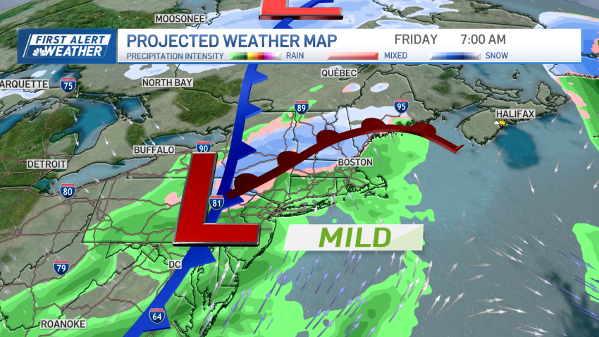
Mild temperatures Thursday, with rain to finish off the workweek
Cold temperatures are on hiatus for a bit as we undergo a small warmup. Sun combines with milder air to boost us into the mid-40s Thursday afternoon ahead of a quick-moving weather system that arrives Thursday night and Friday. Although we’re stressing the warmup, there is still enough cold air around for us to see some wet snow and...
-
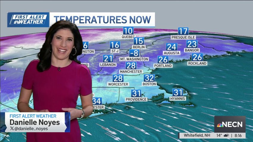
Temperatures warm up Thursday followed by rain to end the week
We had another crisp, cool morning and high temperatures Wednesday will be a tad cooler than normal once again. Highs in the mid to upper 30s are a touch below average highs for this time of the year (40 for Boston). A few clouds move in from the southeast as the day goes by. As the clouds stick around Wednesday…
-

Historic California palm trees come crashing down into ocean amid powerful winter storms
A severe storm that pummeled California has taken a toll on some of the state’s most iconic trees.
-
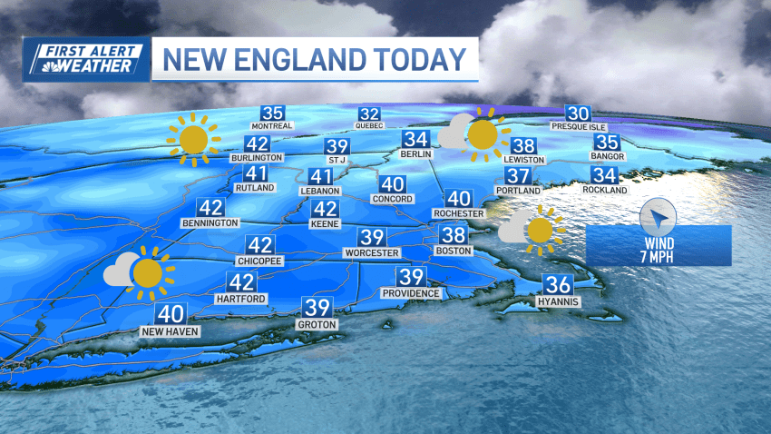
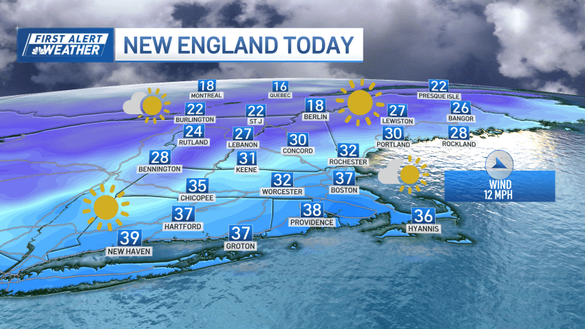
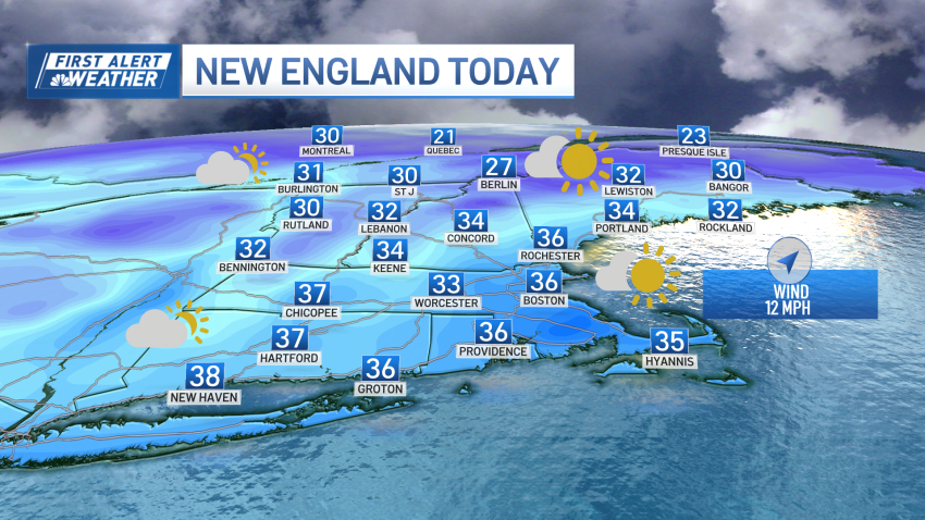
Dry weather rolls on, cold set to relax by week's end
As high pressure – a fair weather cell – from Canada crests over New England, a Tuesday morning breeze goes quiet during the day as cool air remains anchored in the region for the time being. The center of high pressure usually is chock full of dry air and Tuesday is no exception, with the dry air not only ensuring…
-
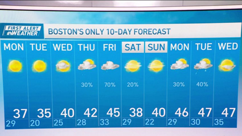
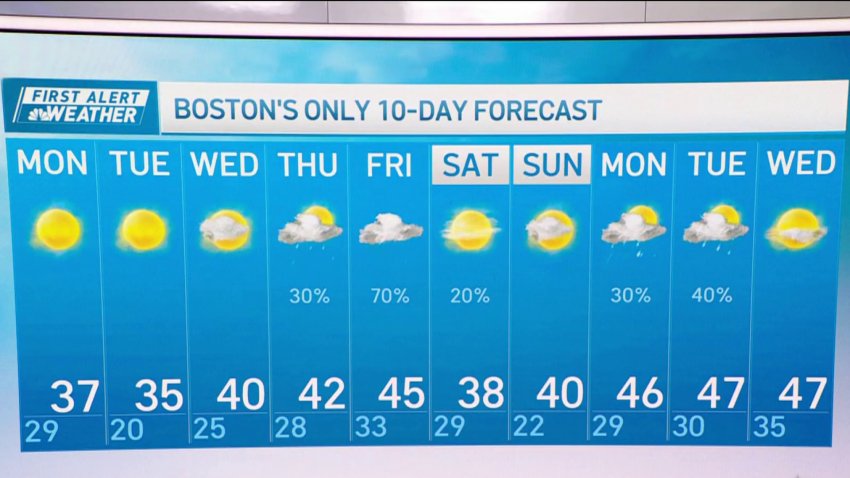
Forecast: What to expect this week, and when we might see snowflakes
Monday: AM flurries to increasing sun. A bit breezy and cool with highs in the 30s. Overnight: Clear and cold. Lows in the teens. Tuesday: Sunshine, a few Cape clouds. Highs in the middle 30s. Wednesday: Sun and wispy clouds. Highs around 40....
...Follow NBC10 Boston on…...
Instagram: instagram.com/nbc10boston...
TikTok: tiktok.com/@nbc10boston...
Facebook: facebook.com/NBC10Boston...
X:... -
Forecast: Quiet stretch, rain later this week
Monday: AM flurries to increasing sun. A bit breezy and cool with highs in the 30s. Overnight: Clear and cold. Lows in the teens. Tuesday: Sunshine, a few Cape clouds. Highs in the middle 30s. Wednesday: Sun and wispy clouds. Highs around 40.
-
Quiet stretch of weather, next chance for rain and snow later in the week
It will be a quiet stretch of weather the next few days, with a big area of high pressure building into the Northeast. The wind continues to add a bite to the air, but will gradually diminish throughout the day Monday. Expect mostly sunny skies and near seasonable high temperatures in the 30s (20s north). With clear skies and a…
-
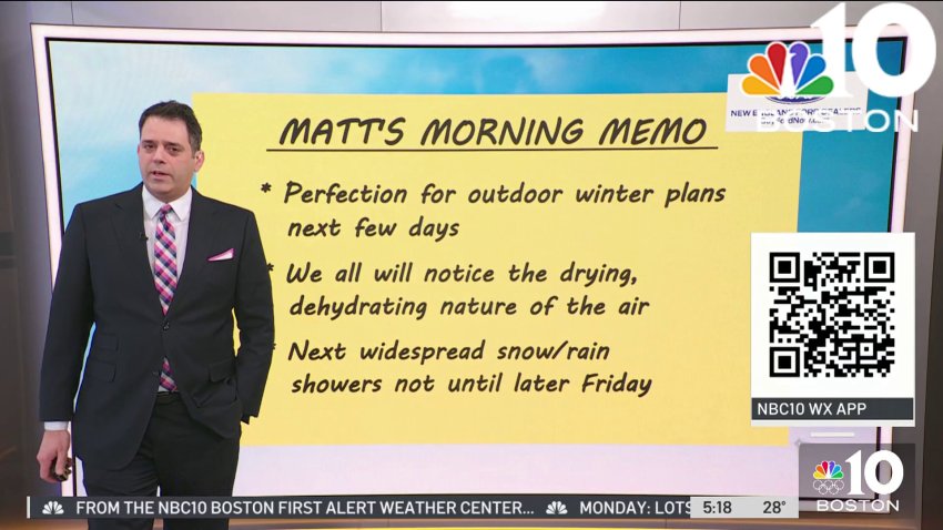
Forecast: Perfect weather for outdoor winter plans
Monday: AM flurries to increasing sun. A bit breezy and cool with highs in the 30s....
...
Overnight: Clear and cold. Lows in the teens....
Tuesday: Sunshine, a few Cape clouds. Highs in the middle 30s....
Wednesday: Sun and wispy clouds. Highs around 40....Follow NBC10 Boston on…...
Instagram: instagram.com/nbc10boston...
TikTok: tiktok.com/@nbc10boston...
Facebook: facebook.com/NBC10Boston...
X:... -
Pleasant winter days and warmer temperatures ahead in Boston
Monday starts dry, blustery, and cold from a low pressure north of New England. Once the low pressure moves east by Monday mid-morning, a wind shift will bring lighter northwest wind. The beginning and middle of the week will be quiet as high pressure takes control. Tuesday and Wednesday will feature lighter winds and sunshine. Both days look like pleasant…
-
Pleasant winter days and warmer temperatures ahead
Monday starts dry, blustery, and cold from a low pressure north of New England. Once the low pressure moves east by Monday mid-morning, a wind shift will bring lighter northwest wind. The beginning and middle of the week will be quiet as high pressure takes control. Tuesday and Wednesday will feature lighter winds and sunshine. Both days look like pleasant...
-
Cloudy and chilly Sunday evening in New England
More clouds than sun will be with us this afternoon as low pressure tracks just north of the Canadian border today into tonight. Snow showers and flurries will develop across the higher terrain of northern and western New England with several inches of snow possible across the highest peaks. The rest of us may see a stray flurry or...
-
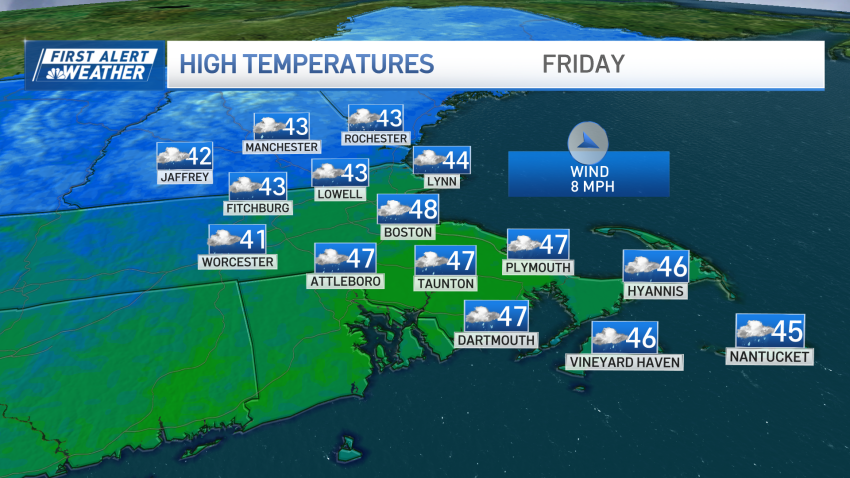
Sunny skies and warmer temperatures ahead of Presidents' Day
Temperatures will reach a high of 47 degrees later in the week following President’s Day. Sunny and partially cloudy skies are expected.
-
Chilly and breezy conditions to continue through Sunday in New England
Cold and breezy conditions persisting through Sunday and into Monday morning. This morning, teens and low 20s for temperatures. When you factor in the wind gusts of 20-45 mph, and it’ll feel more like the single digits and teens. Coastal areas, especially on the Cape, will see the higher end of the range. While inland area wind gusts stay...
-
Chilly Saturday in New England with light snow in the afternoon
Unsettled and seasonably chilly today with lots of clouds around as well as scattered flurries and snow showers. Highs reach the mid 30s south, upper 20s to low 30s north with an increasing northwest wind. A cold front slicing through the region this afternoon will help kick off a line of snow squalls which may produce briefly moderate to...
-
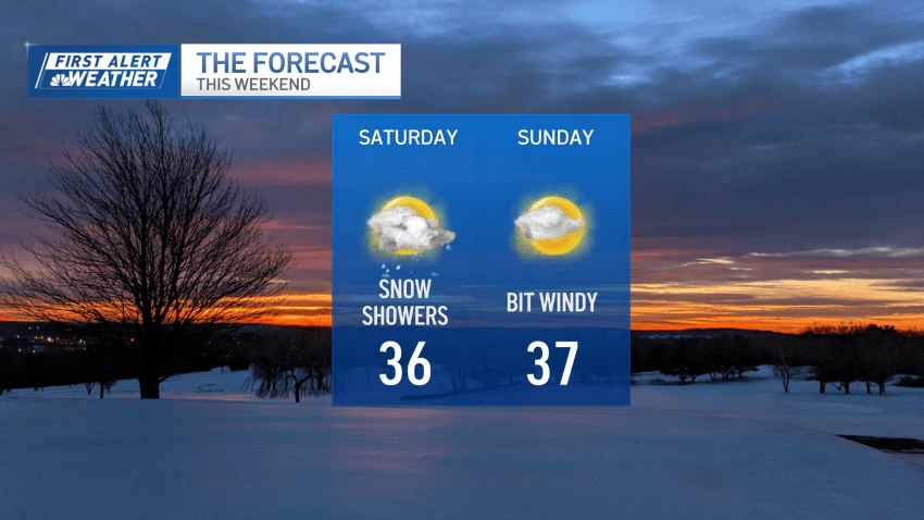
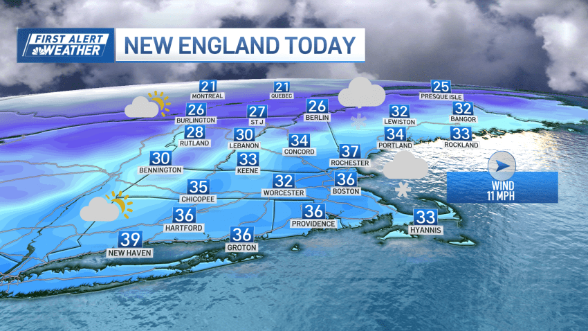
Cloudy Saturday with afternoon snow showers in New England
The wind has eased, for now. We’re watching the potential for some light snow with a quick-moving system to the south ands the possibility of snow squalls in the afternoon across the entire area. Temps will only rise into the mid-30s thanks to limited sun today. We’re not even worthy of the “partly sunny” designator for the sky today....
-
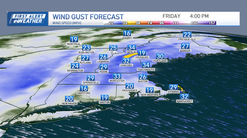
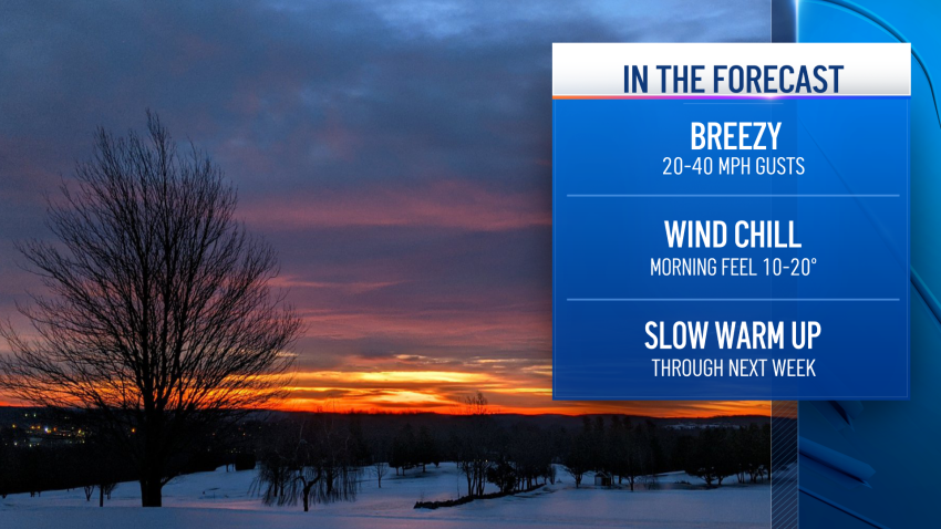
Cold and icy Friday night, with more snow showers on tap for the weekend
Snow showers continue throughout the day in scattered areas as a gusty northwest, west wind takes over. Meanwhile, the mountains continue to see snow showers through afternoon Friday, leading to additional 1 to 3 inches of snowfall on the peaks. As our wind cranks up through noon Friday, we could see some blowing/drifting snow north, with isolated areas of damage…
-
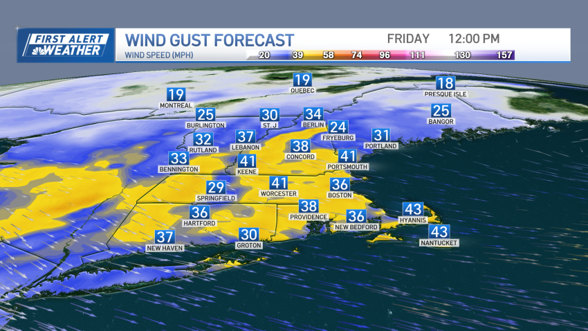
Strong winds, snow showers for some to end workweek
A fresh coating to 2 inches of snow fell overnight. Roads are actually fine Friday morning with temperatures around 32 and the rock salt on the pavement did the job. Snow showers continue throughout the day in scattered areas as a gusty northwest, west wind takes over. Some more robust snow showers may develop on the backside of the departing…
Trending
