
A flash flood emergency was issued for Leominster, Massachusetts, Monday, a relatively rare warning for life-threatening flash flood potential. The expected rainfall rate, according to the National Weather Service, was between 2 to 4 inches in an hour.
Worcester County's flash flood warning will remain in effect until 8 a.m. Tuesday. Flash flood warnings were in place in other parts of Massachusetts, Rhode Island, Connecticut and New Hampshire Monday, but expired Monday night.
See the latest severe weather alerts and track live radar here:
Get New England news, weather forecasts and entertainment stories to your inbox. Sign up for NECN newsletters.
Southern and southwestern parts of New England, including the Boston metro area, were bracing for heavy rain and flooding Monday evening and through the first half of the night.
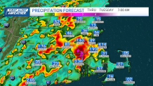
The National Weather Service issued a flood watch for the region, given the forecast for heavy rain, which could cause flooding in low-lying areas — the temperatures have cooled, but the available water vapor in the atmosphere is still peaking. Drivers should be on the lookout for flooded roads.
Weather Stories

It comes after another weekend of deluges. Spotty flooding was reported in areas, but many areas simply received a drenching rain. Top rainfall totals were over four inches in Attleborough on Saturday and almost three and a half inches in Scituate on Sunday.
We’ll catch a break Tuesday before we stare down more rain on Wednesday. This batch is with another water-loaded front. (I’m not liking the trend, either.) We’ll watch the downpours move in during the late morning, but from what the guidance is showing now, another one to two inches of rain could be at stake in some spots.
If that’s not enough of a concern, the track of Hurricane Lee is giving us fits. We’re noticing a slight westward (as in closer to New England) track to the storm into the weekend. While we’re not alarmed, we’re watching the trend very carefully. Surf, beach erosion, rip currents will all be on the rise through the week starting late Tuesday. Keep in touch in the coming days as we narrow the track.
Make it a good week!
