
Monday will begin with snowy, slushy and wet conditions, varying by location. Most of the snowfall will occur before daybreak, with some lingering snow showers possible until noon.
The most challenging commute conditions will be from the Merrimack Valley to Worcester, where accumulations are highest.
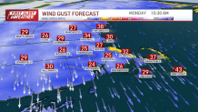
The Cape, South Shore and the Islands may experience another round of snow with light accumulations and wind gusts up to 40 miles per hour into the afternoon.
Get New England news, weather forecasts and entertainment stories to your inbox. Sign up for NECN newsletters.
High temperatures will warm to the mid to upper 30s during the day, creating a slushy mess for the evening commute. The evening commute will be smoother than the morning until temperatures drop quickly below freezing.
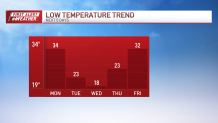
Expect any excess water to freeze overnight as Tuesday morning lows drop to the low to mid 20s, potentially causing icy conditions on roads and walkways.
See all the active weather alerts here and school closings, delays for Monday here
The rest of the week remains relatively quiet until Friday. Tuesday's highs won't quite reach above freezing, but beyond Tuesday, temperatures will stay in the upper 30s and low 40s for highs throughout the week, with lows below freezing each morning.
Keep an eye on Friday, as it has the potential to bring the next system — we'll provide updates as the date approaches.


