
-
Over 50,0000 still without power in Maine and NH as restoration efforts continue on Sunday
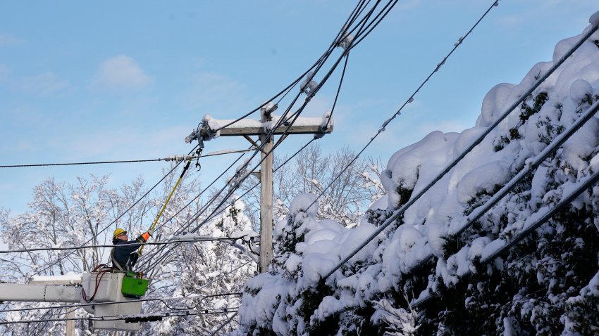
Power restoration efforts in Maine and New Hampshire continued on Sunday with over 50,000 homes and businesses still in the dark several days after a storm brought powerful winds and heavy, wet snow. Maine’s largest electric utility warned that some customers might not have service restored until Monday or Tuesday, despite the efforts of 1,125 line crews and 400 tree-cutting…
-
Thousands still without power in Maine and NH as restoration efforts continue
Thousands of customers are still without power in Maine and New Hampshire as restoration efforts continue on Saturday after a nor’easter blasted the region, dropping nearly two feet of heavy, wet snow in some areas. The weather service said it was the biggest April nor’easter to hit the region since 2020. Central Maine Power said 132,279 of its customers still…
-
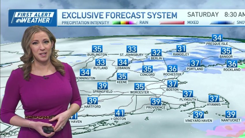
Snow showers linger over parts of New England Friday
Friday: Morning flurries. Cloudy skies. Highs in the mid 40s. Overnight Friday night: Chilly air. Brisk Winds: 15-20mph. Lows in the mid 30s. Saturday: Isolated coastal showers. Highs near 45 degrees. Sunday: Partly Cloudy. Pockets of sun. Highs near 46 degrees.
-
Snowfall totals map: This week's nor'easter dropped 2 feet of snow on parts of New England
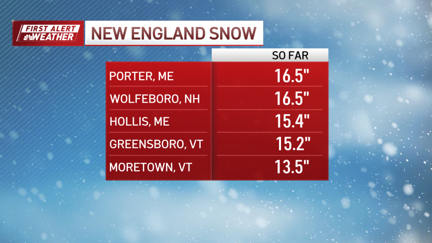
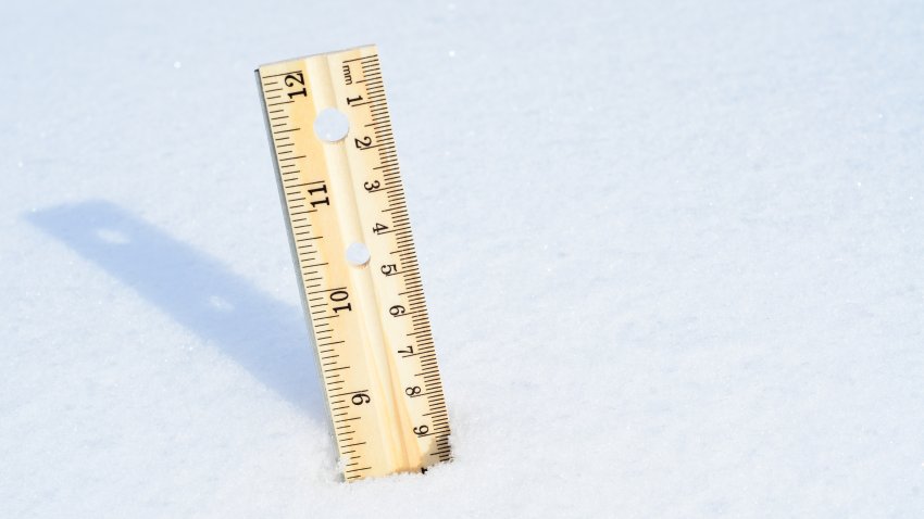
This week’s long-duration nor’easter dropped as much as two feet of snow on some parts of northern New England. The town of Moretown in central Vermont, had seen 24 inches of snow as of 8 a.m. Friday., and a foot or more of snowfall was common across parts of Vermont, Maine and New Hampshire. Here’s a look at some...
-
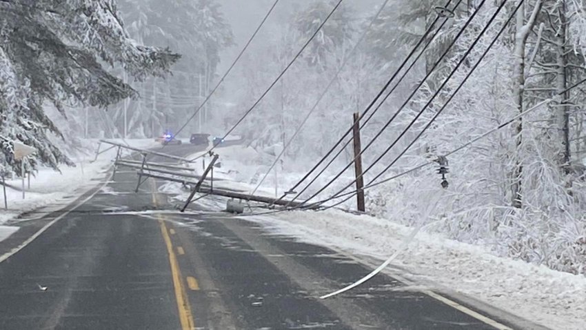
Over 200,000 still without power in Maine and NH amid multi-day restoration effort
Over 300,000 customers are still without power in Maine and New Hampshire after a nor’easter blasted the region, dropping nearly two feet of heavy, wet snow in some areas. “This was pretty much a classic nor’easter,” said Stephen Baron, a meteorologist for the weather service in Gray, Maine. “This is definitely a high-end storm for April. It’s not crazy...
-
Snowfall totals map: Some areas of New England received over a foot overnight
Some areas of northern New England have already received over a foot of snow as a result of the nor’easter that swept across the region overnight. The town of Greensboro, Vermont, had seen 15.2 inches of snow as of 1 p.m. Thursday, and 10 inches or more of snowfall was common across northern Maine, New Hampshire and Vermont. Here’s a…
-
What's up with those forecasts calling for 1-2 feet of snow in New England this week?
Around social media, you may have seen a few wild snow maps predicting 1-2 feet of snow for New England, and even a few inches of snow for Boston. Well, that’s where your friendly meteorologist comes in. Part of our job is to filter out the noise and give you one quick glance at the most accurate forecast for snow. ...
-
HOUR BY HOUR: When will snow arrive in your part of New England
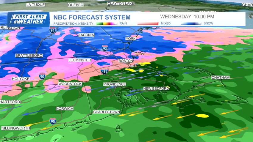
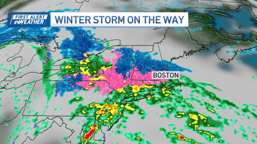
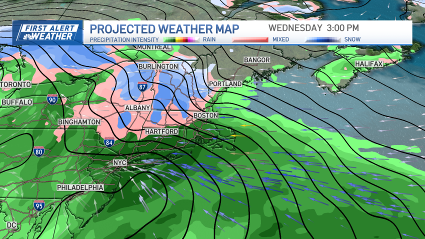
A powerful nor’easter is bearing down on the Boston area Wednesday and Thursday, set to bring widespread precipitation — rain for many and a wintry mix or snow for some, especially in the Worcester hills and New Hampshire. The NBC Forecast System shows the system move into the region at the start of the morning commute Wednesday, dropping widespread rain…
-
A strong storm is headed to New England bringing snow to some
Tuesday evening: Cloudy, scattered rain. Temps in the 40s. Overnight Tuesday night: Cloudy night, few showers. Lows in the upper 30s. Wednesday: First Alert Day. Windy. Gusts near 40mph. Rain and Sleet. Highs in the 40s. Thursday: First Alert Day. Rainy day. Afternoon wintry mix. Gusty Winds. Highs near 40 degrees.
-
A big storm may be coming, but southern New England is still short on snow
A spring storm is heading in for our first week of April. And as models hint at snow (with major snow in the mountains up north)…we miss out again in southern New England. The entire winter into the first month of meteorological spring (March) had a huge lack of snowfall across southern New England. Boston, for example, had only 9.7”…
-
Messy early April nor'easter to bring heavy rain, sleet, snow to New England
We’re staring down one last tranquil weather day before our weather drastically changes. We’re in and out of the clouds Monday, but they should let up around 2 p.m. This will be around the peak heating of the day, so high temperatures approach 60 degrees. Throughout Monday night, a weaker weather system to our south will bring clouds back...
-
Sunny Easter before mid-week storm hits New England
Drier air will continue to flow into the region along with seasonably mild temperatures allowing for some sunny breaks in the cloud cover through this afternoon.
-
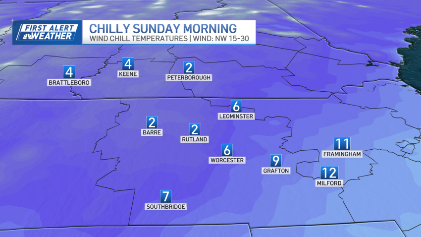
Cold air comes in as winter storm winds down in New England
Sunday morning starts with single digit wind chills and cold air overhead.
-
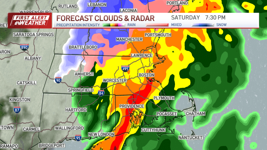
FIRST ALERT: Storm brings large accumulations of snow and rain to New England
The heaviest rain is expected to taper off between 8-9 pm.
-
FIRST ALERT: Storm to bring large amounts of rain through New England
And you thought winter was over. Our storm started as snow – with a coating to as much as an inch in spots overnight – but the second act promises to deliver in the rain department. Some colder holdouts in Northern Mass and Southern New Hampshire are over to ice this morning, but even here, the temps will gradually warm…
-
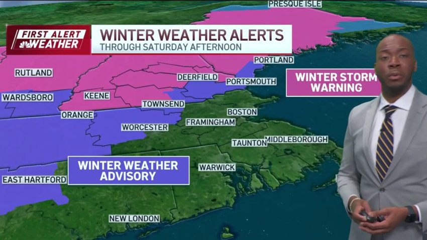
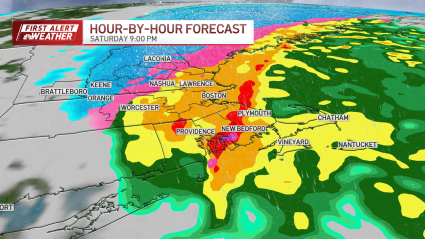
Forecast: Winter storm warning for parts of New England Sat.
Overnight Friday night: Rain and snow arrives. Lows around 30. Saturday: Early AM snow north of the Mass. Pike turns to steady rain, except heavy snow northern New England with 8″-16″. Highs in the 40s for most. Sunday: A veil of clouds, wintry breeze. Highs around 40, wind chill around 30.
-
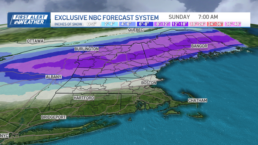
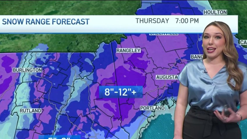
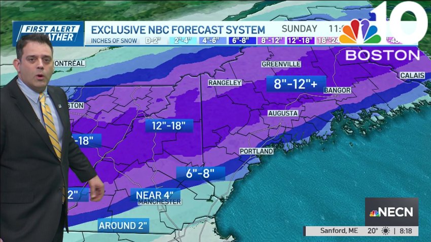
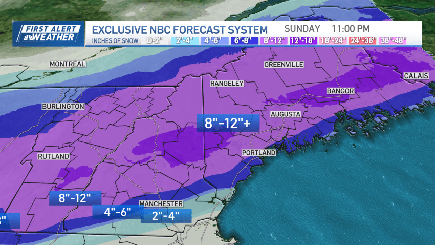
FIRST ALERT: Major winter storm for northern New England Saturday, 8-12 inches of snow possible
A First Alert continues for the northern half of New England for Saturday as we await what will amount to a significant winter storm in Ski Country. While this is great news for skiers, winter storm driving conditions are anticipated throughout the day there. But first, we start with a quiet Friday – the dew point temperature, or measure of...
-
-
First Alert issued for Saturday, heavy snow expected in northern New England
Winter has returned in full force on Thursday with gusty west winds, wind chills in the teens and 20s, highs in the 30s, and some lingering flurries. More specifically, in Maine we continue to see the low pressure system slowly move out Thursday, but lingering snow showers continue to coat untreated backroads with fresh snow. The morning flurries across...
-
Some areas of northern New England received up to a foot of snow overnight
Massachusetts saw a few snow squalls overnight, but other than that, most of the state saw only rain. But some areas of northern New England saw up to a foot of snow, and another storm that could bring accumulating snow is headed our way this weekend. Here’s a look at some of the jackpot areas for snowfall, according to...
Trending
