Severe thunderstorm warnings that were issued late Saturday afternoon for parts of central and western Massachusetts, including Worcester, Hampshire, Franklin and Hampden counties, have since expired, as have flash flood warnings that were issued for parts of Mass., New Hampshire, Connecticut and Maine where thunderstorms produced heavy rain.
Click here for active weather alerts in Massachusetts and all of New England.
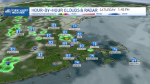
The warmth and humidity remained Saturday afternoon, with showers and storms developing west of Interstate 495 into the White Mountains. A more widespread rain event will be expected Sunday into Monday with locally heavy rainfall that may lead to street flooding.
Get New England news, weather forecasts and entertainment stories to your inbox. Sign up for NECN newsletters.
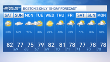
This afternoon we’ve got highs in the 80s that for some communities inland heat indices rise to the low and mid-90s. while the chance of rain for Boston today is only a shy 35%, a few isolated showers will linger into Middlesex and Essex county in the middle of the afternoon with some of it spreading into the Merrimack Valley.
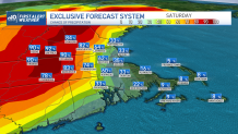
The heavier rain, though, is expected to strengthen on the second part of the afternoon west of Worcester and Leominster towards the Monadnock Region and spreading into the white mountains.
Heavy rain may produce exceed an inch to two under the strongest downpours in the early evening. Most instability will wind down tonight keeping mostly cloudy skies across the region.
While humidity won’t change tomorrow, temperatures will dip with the increase in cloud coverage. These clouds will give way to showers and storms developing across western New England Sunday afternoon into Monday.
Starting in the Berkshires and up to the green mountains, a cluster of storms will begin to develop by the early to mid-afternoon and will push northward through the evening with a slow but steady march into the Monadnock region by the late afternoon and towards the early evening.
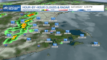
These showers may spread as far east as Worcester and clip near I-495. With the loss of the daytime heating tomorrow, most of these storms will begin to weaken but the energy should meander across the 6 states through Monday which will set the stage for potentially strong to severe storms Monday.
With Monday’s rain and storms we may see locally heavy rainfall again which may give way to street flooding, strong localized wind gusts and cloud to ground lightning. We’ll be on the lookout for potentially strong to severe storms Monday starting in the late morning hours into the afternoon.
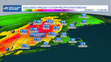
We may generally see over 2 inches of rainfall across western MA, VT and NH by Monday night but localized areas may see just over that where the heaviest of the downpours and storms march through.
Your NBC10 Boston & NECN First Alert Team will stay tuned to the development of these storms and keep you informed at all times.