
Parts of Massachusetts woke up with rain, snow and a wintry mix early Tuesday morning. As drier air continues to fill in, most of it has dissipated with only a few light rain showers across the southeast and East Coast with left over flakes over Maine that should come to an end Tuesday night.
This evening will bring slowly clearing skies and dropping temperatures that take us to the 30s inland and low 40s overnight for Boston and the south after an afternoon with highs in the 40s.
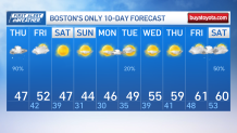
Our Friday will feature cloudy skies with highs in the low 50s, which is near to slightly below average for the Boston area. The west wind will gust up to 25 miles per hour, which may just keep it feeling a couple degrees cooler as the sun will be covered by clouds.
Get New England news, weather forecasts and entertainment stories to your inbox. Sign up for NECN newsletters.
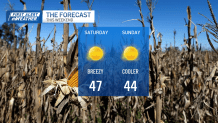
The weekend promises bright skies ahead. While temperatures will stay below average, no rain or snow will threaten the area.
Highs will vary in the 40s, and the bright sunny skies will stay through Monday with temperatures dipping to the low 40s with overnight temperatures in the 20s.
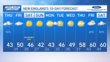
Early Tuesday may bring light precipitation for a few as a low may near the area, but by Wednesday a high pressure system takes over and welcomes a milder trend that returns our sunshine and highs in the 60s Friday into the following Saturday.
