
Sunshine gives way to clouds Monday as warmer air starts making a move toward a frigid New England.
Coming off record cold arctic air this past weekend, a collision with incoming warmth will mean thickening clouds give way to first snowflakes from the south coast to the Massachusetts Turnpike from 4 p.m. to 7 p.m., respectively, then snow expands north this evening.
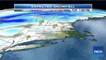
In southern New England, only about a coating to two inches of snow will accumulate before changing to a period of freezing rain that will last longest through the interior, ensuring slick driving conditions continue through the overnight.
Northern New England sees a heavier burst of two to four inches of snow before changing to Tuesday morning freezing rain. Eventually, Tuesday brings windy warmth for scattered plain rain showers that will culminate with downpours and a chance of thunder late, with scattered damaging southeast wind gusts to 55 mph possible near the coast.
Most of us dry out Tuesday overnight but the mountains will end with some snow squalls before a dry Wednesday, then seasonable air to end the week. More mild rain showers are possible Saturday, though Sunday is looking good and no brutal cold returns to the 10-day forecast.
