The respite between storms for New England extends through Thursday and Friday before our next storm system arrives Friday night through Saturday morning.
For now, the energy set to form that storm is still in the western United States, far from home and affording time for quieting weather as a westerly breeze continues to ease Thursday while sun and clouds battle in the sky above.
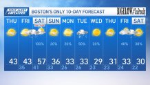
Temperatures in the lower 40s are slightly above normal for this time of the year and a slackening afternoon wind means the air won’t feel too abrasive for New Englanders. Most rivers are receding, and with the exception of the slow-to-rise Charles River in eastern Massachusetts, which will continue rising through the weekend, most other rivers that haven’t crested yet will reach their peak levels Thursday afternoon or evening.
A weakening disturbance aloft arriving from the Great Lakes on Thursday afternoon will brew up a few snow showers in northern New England, with only an evening flurry or sprinkle in southern New England before skies clear and most temperatures drop below freezing, which means a very isolated slick spot may result where the flurries and sprinkles are able to wet the ground.
Get New England news, weather forecasts and entertainment stories to your inbox. Sign up for NECN newsletters.
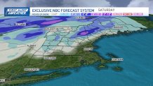
Otherwise, dry weather continues until the next storm – picking up moisture from the Gulf of Mexico as it enters the eastern United States – arrives with the front edge of its rain and snow shield sometime near midnight Friday.
How many inches of snow on Friday?
While exclusively rain will fall for most of southern New England, the Berkshires to northern Worcester County will start with a brief period of snow and light accumulation, and snow will last deeper into the night the farther north one is, with a 6-12 inch burst expected in the northern New Hampshire and Maine mountains!
At the same time, this storm is taking a similar track to our previous storm, meaning winds will increase after midnight Friday night through Saturday morning, with gusts over 50 mph possible in eastern New England and also along the western and northwestern slopes of our northern mountains.
Track the storm with live radar
Local


The southeast wind direction will pile water along the coast, like we saw Wednesday, and this means spots like Hampton, New Hampshire, are vulnerable once again, though all of the coast will be on guard as a New Moon pushes tidal levels up in addition to the effects of the wind.
Though one to two inches of rain will send river levels up again and should result in at least some renewed flooding, that rain breaks into just a few leftover showers with breaks of sun Saturday afternoon.
The morning wind turns gusty but non-damaging in the afternoon as it shifts to blow from the southwest and mild air will linger through much of the day with temperatures in the 50s for much of southern New England and 40s north.
Snow next week?
New, colder air arrives Saturday night and holds temperatures some 20 degrees colder on Sunday, even under a fair sky! This new, cold air sets the stage for a nearby storm next Tuesday to drop accumulating snow for most if it tracks close enough to New England, and that may repeat with another storm sometime around next Friday to Saturday into our exclusive First Alert 10-day forecast.