I have a confession. The overall look and feel of the pattern is more about spring than it is about winter. Sure, there are threats for snow (namely next week), but they're bookended with warmups and brief cooldowns - not prolonged cold snaps and bitter surges of air.
Of course, now that I've said that, it should snow through April.
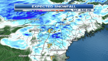
A warm front approaches Friday night with a band of light snow that will eventually mix with and change to rain. Generally light amounts are expected regionally as we remain on the southernmost edge of the precipitation.

The snow will be a little more significant north of Bennington, Vermont; Concord, New Hampshire; and Biddeford, Maine.
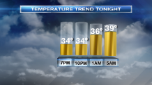
With rising temps, however, accumulations won't be significant. In fact, by morning, most of us will switch to rain with temperatures hovering near 40 by daybreak in Southern New England.

And that gives more credence to the idea of mid 50s in parts of Southern New England tomorrow afternoon. With a little help from the sun, we should hit 54 or 55 in Taunton, Raynham, Middleboro, and even as far north as Norwood and Foxborough in Massachusetts.
Local
A cool front will come sweeping in during the late afternoon and evening, triggering a few robust rainshowers in Northern New England and a passing shower in Massachusetts. It will turn the temperature a bit cooler for Sunday, but I still think 50 may be within reach in the aforementioned communities.
Attention then turns to the threat for snow next week.
Sunday night and Monday, a quick-moving system will scoot by just to our south. The trend has been to push this farther offshore, so much so that I don't believe it will be any more than some clouds and a passing shower Sunday evening in Southeast Massachusetts.
Enough said there.
Tuesday night and Wednesday look to be a bit more ominous. Here too, the trend has been warmer, so I'm "feeling the heat" to mention a switch from snow to rain with the building storm. The good news is we're still on par for a significant snow event in Northern New England - great shot in the arm for the ski resorts. However, this storm is big, and it may get dragged into Thursday. Lots to work out in the days ahead, but prepare for some travel issues - or even coastal flood threats as this is a nor'easter - Wednesday and Thursday next week.


