It seems like we can’t catch a break lately with one powerful storm after another barreling through the region.
Saturday we found ourselves on the tail end of a fast moving system which has made quite an impact in terms of heavy, flooding rains, strong winds, coastal flooding, and accumulating snow across northern New England.
Thankfully, the rain is pretty much done across southern areas where we saw anywhere between 1-2” with locally higher amounts, which has led to localized flooding in the usual prone areas as well as along some rivers and streams, which we’ll closely monitor through the afternoon.
Get New England news, weather forecasts and entertainment stories to your inbox. Sign up for NECN newsletters.
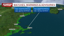
Flood warnings for Mass., Maine, Rhode Island
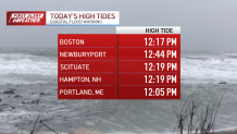
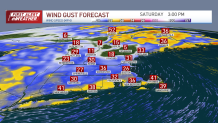
Another major concern is the coastline due to an astronomical high tide early this afternoon in conjunction with strong southeast winds which helped to pile up the water there. A coastal flood warning is in effect through this evening with some minor to moderate flooding possible along the Massachusetts, Rhode Island, and Connecticut coastlines.
Moderate to major flooding is expected along the New Hampshire and Maine coastlines where we could see unprecedented water levels, even higher than earlier this week. It is so important to inform our valued viewers to please stay clear of flooded areas for your safety.
Maine Governor Janet Mills urged Maine residents to stay home if possible as water levels rise in the state due to the storm.
Local


Portland Police are also asking citizens to stay off the roads due to the weather.
"We are expecting unprecedented storm surges and flooding today, with the worst expected at 12. Somerset St. is already closed. We are advising people to stay off the roads and be safe until this surge has passed. Do not, under any circumstances, drive through flooded roads." they wrote on social media.
A clearer Saturday evening
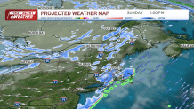
The good news is our system will wind down this afternoon with partial clearing and mild temps south, stays cold north where we’ll see precipitation ending later this evening, mostly as snow across the higher elevations where we could see over a foot. Highs in the 50s south, 30s and 40s north with winds switching to the southwest, gusting over 30 at times.
It'll be drier and breezy tonight with a few clouds around, a couple lingering flurries and snow showers across the higher terrain, especially northern Maine.
Track the storm with live radar
What's next?
Lows drop into the 30s south, 20s north. We stay windy tomorrow with a game changing cold front slicing through the region during the day which is looking more likely to produce widespread snow squalls capable of dropping a coating to an inch or so of snow and lowering visibilities at times…be on the lookout for those! Highs tomorrow mostly in the 30s, close to 40 south with a gusty West/Northwest wind developing.
Breezy and colder MLK Day with highs struggling to break freezing south, 20s north, a gusty west/northwest wind will make it feel colder. Next chance for snow arrives Tuesday into Wednesday, still some details to work out with that one, stays cold beyond that which is featured on our Exclusive 10-Day Forecast.