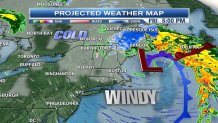
Snow this morning, then heavy pockets of rain this afternoon, to blustery conditions for Friday.
--> THE LATEST SEVERE WEATHER ALERTS <--
It was another frigid start this morning, with temperatures into the mid- to upper-20s for most. As a system from the west slid into western New England this morning, snow started falling into western Connecticut and higher elevations in western Massachusetts.
--> INTERACTIVE WEATHER RADAR <--
As this low pressure system tracks eastward throughout our Thursday, by noon temperatures will be into the upper 30s and we’ll see the rain/snow line into Worcester County, Massachusetts. For eastern Massachusetts, it will just be a rain event, with rainfall totals of at least 1 inch through Friday evening.

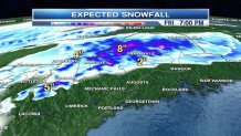
What everyone wants to know is how much snowfall is expected for western and far northern New England. For the Berkshires in western Massachusetts, between 1 to 2 inches of snow is possible, with slightly higher amounts in higher elevations through Friday evening. A Winter Weather Advisory has already been issued for parts of Maine through Friday.
Local
--> ENABLE SEVERE WEATHER ALERTS ON THE NECN APP <--
With the timing of the system along with the northwesterly flow moving in on the backside of the system, the Green Mountains, the Northeast Kingdom, northern New Hampshire, and the Crown of Maine are all areas that will receive between 4 to 8 inches of snow through Friday night.

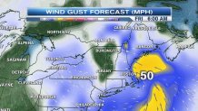
Some localized power outages are possible as the wind gusts pick up to round out of the work week. We could see gusts between 40 to 50 mph, especially along the coastline, which has prompted wind advisories and gale warnings to be issued for overnight tonight into Friday morning.

Saturday does bring another round of showers - mainly rain showers - as another system slides through.
Sunday looks to be the driest day of the weekend, and Halloween on Monday remains dry. As always, stay tuned for the very latest forecast updates on necn and www.necn.com.


