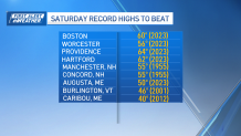
Who’s ready for some record breaking warmth? We’re on the edge of much milder air that will stream into the region on Saturday, with highs expected to push well into the 50s and even eclipse 60 in a few spots.
Before we get there, Friday is our transition day: clouds will gradually give way to breaks of sun, pushing our temperatures well into the 40s, though it takes much of the day to get there.
Areas of low clouds and patchy dense fog will fill in Friday night as temperatures drop into the mid to upper 30s, though a few northern New England locations will be near or just below freezing, so watch for some patchy black ice development in central/northern New Hampshire and central/northern Maine.
Record-breaking warmth Saturday
Get New England news, weather forecasts and entertainment stories to your inbox. Sign up for NECN newsletters.
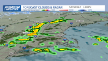
Once the clouds and fog burn off Saturday, which may take until midday or early afternoon, we’ll see our temperatures spike into record breaking territory. As a cold front approaches later in the day, we’ll have to dodge some scattered showers, a few downpours and maybe even a rumble of thunder generally between 2-8 p.m. from northwest to southeast across the region.
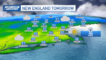
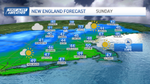
Behind the front, we’ll be slightly “cooler” but still above average on Sunday, with highs in 40s to around 50 south. It’s worth noting that tides are astronomically high thanks to the new moon, which will result in some splashover and pockets of minor coastal flooding during the afternoon high tide cycles Saturday and Sunday.
Snowstorm coming next week: How much will Mass., NH get?
Local


Temperatures will still be mild on Monday before a cold front approaches from eastern Canada. This front will usher in colder air, and also interact with an ocean storm developing to our south.
The storm looks to come close enough Monday night into Tuesday for a period of rain and snow to develop, though the exact track will determine how much, if any, snow we receive. A track farther offshore would result in lower totals, and perhaps only snow in far southern New England, while a track closer to the coast would mean some higher totals inland with a mix of rain coming into play.
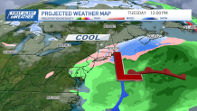
Either way, as it departs, colder air moves in with a snap back to reality next week with highs only in the 30s.
Next weekend looks unseasonable cold and dry with highs in the 20s to around 30 as seen in our exclusive 10 day forecast.