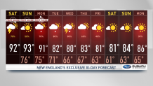
Another tropical and sizzling afternoon across New England. Dew points remain in the 70s and highs in the 90s. Little change is expected on Sunday.
Grab an ice cream, dress in lightweight clothes and stay cool through the weekend, our temperatures feel near 100 on Saturday and increase a bit more on Sunday.
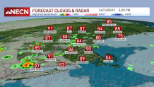
Thunderstorms began late morning and continue to develop this afternoon. Most of the activity is headed north and northeast. While some areas in Massachusetts remain prone to more rain and thunder through the evening, the chances for precipitation diminish across the cape and southern counties.
Get New England news, weather forecasts and entertainment stories to your inbox. Sign up for NECN newsletters.
Our rain and storm chances redevelop Sunday afternoon, bringing the potential for more loud thunder, localized strong wind gusts and heavy rain.
As far as temperatures go, our heat advisories will remain in place through Sunday. Dew points hang on to the 70s through Monday.
From early to mid-week, we’ll see a frontal boundary stalling in northern New England and shifting slowly south. This will increase lifting in the atmosphere and enhance the potential for severe weather.
Rain chances remain through the second half of next week, but temperatures take a dip into the lower 80s, bringing more seasonable temperatures. Those nice 80s remain on hold through the beginning of next weekend.