
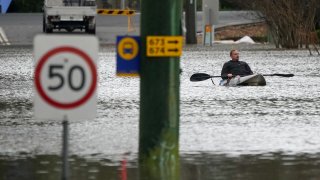
Parts of Australia’s largest city have been inundated by four major floods since March last year, leaving weary victims questioning how many times they can rebuild.
The latest disaster follows Sydney’s wettest-ever start to a year with dams overflowing and a sodden landscape incapable of absorbing more rain that must instead run into swollen waterways.
Here are the climate, geographic and demographic factors behind Sydney’s latest flooding emergency.
___
Get New England news, weather forecasts and entertainment stories to your inbox. Sign up for NECN newsletters.
LEADERS BLAME CLIMATE CHANGE
New South Wales state Premier Dominic Perrottet said government and communities need to adapt to major flooding becoming more common across Australia’s most populous state.
“To see what we’re seeing right across Sydney, there’s no doubt these events are becoming more common,” Perrottet said on Monday.
U.S. & World

Prime Minister Anthony Albanese said the fourth major flood event across Sydney following devastating wildfires in the same region during the 2019-2020 Southern Hemisphere summer were evidence of the need for climate action.
“What we know is that Australia has always been subject of floods, of bushfires, but we know that the science told us that if we continued to not take action globally on climate change, then … extreme weather events would be more often and more intense,” Albanese said on Wednesday.
“What we’re seeing, unfortunately, is that play out,” Albanese added.
___
LA NIÑA OUT, OTHER WEATHER PATTERNS IN
Two La Niña weather patterns brought above-average rainfall across Australia’s east coast in 2021 and this year. The second was declared over last month, but the Bureau of Meteorology forecast a wetter than usual Southern Hemisphere winter for Sydney and a 50-50 chance of La Niña returning this year.
The bureau says two climate drivers led to Sydney's flooding since Saturday.
The flooding was influenced by the Indian Ocean Dipole, which refers to the difference in sea surface temperatures between the western and eastern Indian Ocean. In the negative phase, warmer waters concentrate near Australia, leading to above-average Southern Hemisphere winter–spring rainfall as more moisture is available to weather systems crossing the continent. The IOD has repeatedly dipped into its rain-bearing negative phase in the past month and is expected to stay negative within months.
A second influence was the positive Southern Annular Mode. The SAM refers to the non-seasonal, north-south movement of the strong westerly winds that blow almost continuously in the mid to high latitudes of the Southern Hemisphere. In the positive phase, the SAM directs more moisture-filled air than usual into eastern Australia, driving above-average rainfall and more east coast lows in winter.
During the latest rainfall event, extraordinarily warm waters off the Australian coast, 21 to 23 degrees Celsius (70 to 73 degrees Fahrenheit), provided extra energy and moisture to a deep trough and east coast low, concentrating heavy rainfall to one 24-hour period that started at 9 a.m. Saturday.
Several rain gauges in Sydney and its surrounding area set July or all-time records.
___
GEOGRAPHY AND DEMOGRAPHY
Much of Sydney’s rain drains into a river system prone to spilling over, but economic interests have largely blocked moves to mitigate flooding.
A 22,000-square-kilometer (8,500-square mile) rain catchment covering the Blue Mountains on Sydney’s western fringe and the city of 5 million’s western suburbs drain into the Hawkesbury-Nepean river system, which is the epicenter of some of the worst flooding.
The river system faces an extreme flood risk because gorges restrict the rivers’ seaward flow, often causing water to rapidly back up and spill across the floodplain after heavy rain, said Jamie Pittock, Australian National University professor of environment and society.
The Hawkesbury-Nepean Valley was home to 134,000 people and that population was projected to double by 2050 as Sydney’s population and real estate prices grow, he said.
“The potential economic returns from property development are a key driver for the lack of effective action to reduce flood risk,” Pittock said.
The state government wants to raise the wall of the Warragamba Dam, Sydney’s main reservoir, to reduce flooding in the valley.
But some argue that raising the wall would control only half the floodwater and won’t prevent major flooding delivered by other rivers in the region, said Dale Dominey-Howes, Sydney University’s professor of hazards and disaster risk sciences.
