
We'll see a mini warmup Wednesday, but it will be fleeting. Breezes make it feel chilly, and the sun will dart in and out of the clouds. Things get a little bumpy as we move through the evening and a vigorous cold front approaches.
The front is supported by some strong wind and lots of lift in the upper atmosphere. This will get the winds to crank after is passage and promote the development of a storm at the surface.
We're at the first stage of the intensification, so it won't mean much other than some wind and falling temperatures, but there might be enough cold air funneling in to change the rain showers over to wet snow in the Worcester Hills. It's there we may see some spotty coatings.
Get New England news, weather forecasts and entertainment stories to your inbox. Sign up for NECN newsletters.
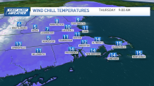
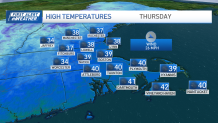
Cold continues to pour in overnight Wednesday, leading us to a wintry feel Thursday morning. With gusts near 40 and wind chills in the single digits and teens, it's spring in name only. We'll only recover to mid and upper 30s during the afternoon.
Things aren't much different on Friday, with more wind (at lighter speeds) and highs in the low 40s. At least the sun will be out both days, right?
Saturday features another storm and more wet weather. However, with aforementioned cold still around, we could see some mix at the onset of the storm in central Massachusetts and southern New Hampshire.
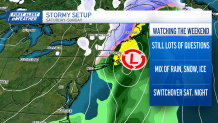
Eventually, the warmer air will work in during the afternoon, but then colder air on the backside of the storm could be enough to recreate some mix Saturday night and Sunday.
Weather Stories

This "backside" mix will be limited, however. We're not seeing signs of any serious accumulation.
Chilly air returns through the early week as the Sun struggles to come back into view.
