
The wintry winds have returned! This is a taste of the winter that never ends. Below normal temperatures will carry us into the weekend.
But that wind. Yikes! Wind chills are down in the single digits and teens Thursday morning, only recovering to the mid-20s Thursday afternoon. Winds themselves, besides biting, are surging to near 40 miles per hour at times Thursday. At least the sun's out?
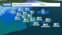
We'll back off the winds Friday. Temperatures recover a little, but they stay below normal right into the weekend.
Get New England news, weather forecasts and entertainment stories to your inbox. Sign up for NECN newsletters.
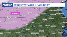
Snow, rain expected Saturday
There may be a bump in the temps by Saturday as a juicy, windy storm comes to town. Initially, there may be enough cold air in place across central Massachusetts and southern New Hampshire to see some mix/sleet/snow, but we're talking about a real water-maker here elsewhere.
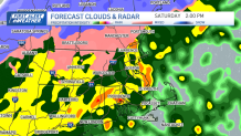
Guidance is consistent with the idea of at least 2 inches of rain falling through Saturday evening. This is an all-day rain, so there are no dry spells, lulls or "taper to sprinkles" until we get to nightfall.
Thankfully, we'll dry out on Sunday. Can't promise a lot in the way of sun (same goes for Monday) thanks to onshore winds feeding a low cloud deck. And we'll see temperatures flop back to the 40s as well.
All in all, not the prettiest weekend to ring in spring. Let's hope we get a chance to dry it at some point this season.
