
Heavy rain is threatening to bring flash floods to parts of Connecticut Friday, after our stretch of amazing weather ends.
That stretch continued for one more day, Thursday, as early morning dense fog patches eagerly yielded to sun, though a hazy appearance in the sky continued courtesy of Canadian wildfire smoke that will also reduce air quality slightly to “moderate” – not unhealthy, but lowered enough that those with respiratory ailments may notice the difference.
Otherwise, a light onshore wind continues to suppress temperatures slightly in coastal communities relative to inland counterparts, but nearly all of us warm to “room temperature” by afternoon with high temperatures generally 65 to 70 degrees.
Get New England news, weather forecasts and entertainment stories to your inbox. Sign up for NECN newsletters.
To our south, over the Atlantic waters off the Mid-Atlantic coast, the same, prolonged storm that bothered us with clouds and showers early in the week is ready to receive new jet stream energy dropping southeast from the Ohio Valley and this will cause the storm to grow and strengthen again. The result will be a return of clouds, showers and cool, moist air on a continued east and northeast wind off the ocean, though it doesn’t all come at once, and doesn’t arrive for all.
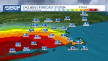
The first sign of change will be increasing Friday late evening and overnight clouds with scattered sprinkles and light showers in southern New England overnight Friday night. What’s interesting is just how fiercely dry air in place across New England ahead of these showers will battle back – in fact, with the exception of Connecticut and western Massachusetts, where rain expands Friday, most of southern New England only sees occasional light showers or sprinkles through much of the day, with more expansive showers not organizing until later in the day, then lasting into the evening.
Our team has issued a First Alert for Friday and Saturday morning because of excessive rain and flash flood potential for Connecticut. A slow-moving low pressure can produce 1-3 inches of rain there, and even higher amounts in isolated places.
Weather Stories

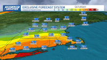
Of course, the abundance of clouds will mean a cool Friday for many, though more sun will be found in northern New England, where rain never arrives at all. Saturday starts with lots of clouds in the southern half of New England, but showers will already be retreating southward and out of northern Massachusetts, then will continue to very slowly peel southeast during the day, with Cape Cod and southeast Massachusetts likely finding at least some showers into the afternoon.
Even where drying takes hold, many will still find stubborn clouds until later in the day, keeping temperatures in the lower 60s for most though, again, northern New England will be a bit milder. Sunday brings a return of plentiful sun regionwide and temperatures will respond by rising into the 70s for most! As a huge dome of high pressure – fair weather – parks over New England for days on end, next week continues to bring sunshine and pleasant air with high temperatures in the 70s and no returning showers expected until perhaps some scattered showers at the end of our exclusive First Alert 10-day forecast next Friday and Saturday.
