


From the NBC10 Boston First Alert Weather Center…. Today: Mostly cloudy, temps reach the low 40s, feeling in the upper 30s (Milder than yesterday). Tonight: Lows drop near 30, mostly cloudy skies. Friday: Slight chance of rain and flurries due to the ocean storm tracking offshore. Chance of showers is 50% for Boston. Cape Cod Radio Forecast: Today: Highs near the mid-40s, mostly cloudy skies. Calm wind from the south @ 5mph. Tonight: Lows drop to the upper 30s with a chance of rain late night into early AM. Friday: Rain and snow potential. Begins as rain with above freezing temperatures and drops after 4pm bringing the chance of snow. Highs in the 40s, dropping to teens through the night. Strong wind gusts could reach 55 mph. (Wind chill will be a factor as well)
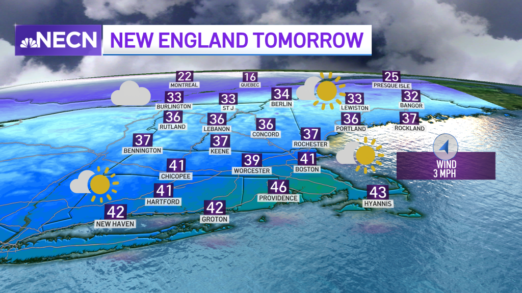
We enjoy a mild day Thursday, with our highs reaching the 40s -- and it actually gets to feel that way without the strong wind gusts we had yesterday.
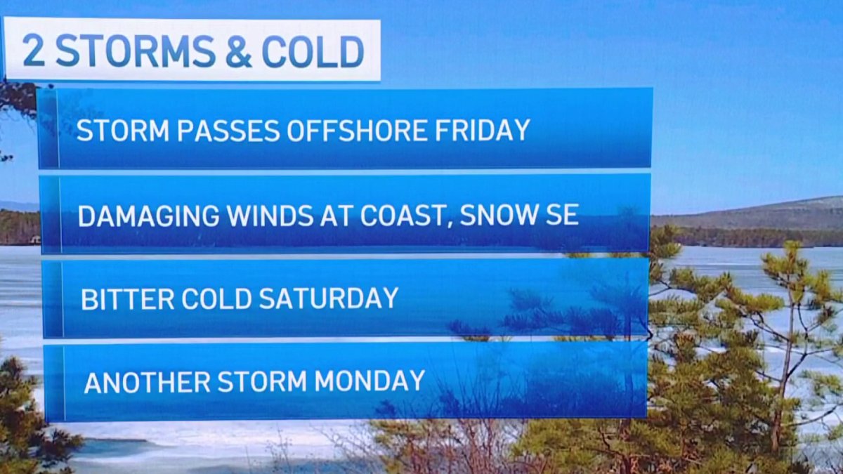
Now our focus turns toward the ocean storm tracking to our southeast Friday morning, bringing rain and the chance for some snow in some spots.
Even though we’re not expecting much in the way of total snowfall amounts -- a dusting to 2 inches max -- our precipitation begins as rain, with temperatures checking in the 40s early and then transitioning into snow as temperatures tend to decrease for the late afternoon and evening.
Get New England news, weather forecasts and entertainment stories to your inbox. Sign up for NECN newsletters.
We’ll be watching a decrease in temperatures over the course of the day Friday, dropping to the 20s at night, along an increase in wind speeds.

The highest concerns for Friday would be possible flash freezing into Saturday morning, bringing slick spots on roads across the southeastern areas that get precipitation, plus potentially damaging wind gusts that could range from 50-60 mph in the most affected spots -- mainly Cape Cod and the Islands.
While Saturday will have the lowest afternoon high temperatures, our coldest wind chills will take place Friday night into Saturday morning, bringing a “feels like temperature” between -10 to -20 degrees. The further north you go, the colder it will feel.
While Sunday rapidly increases into the upper 20s, a storm is on tap for Sunday night into Monday.
Weather Stories


The storm on Monday will bring rain and snow. While the rain/snow line is still being analyzed, our snowfall totals are looking to be higher in the northern and western portions of New England. Preliminary amounts have us ranging from 6-8 inches in the highest elevations across the north.
In our exclusive 10-day forecast, you’ll see First Alert Stamps for Friday and Monday, with cool temperatures remaining through next week. Stay tuned for the latest updates.


