
-
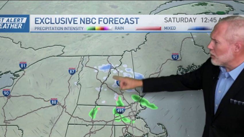
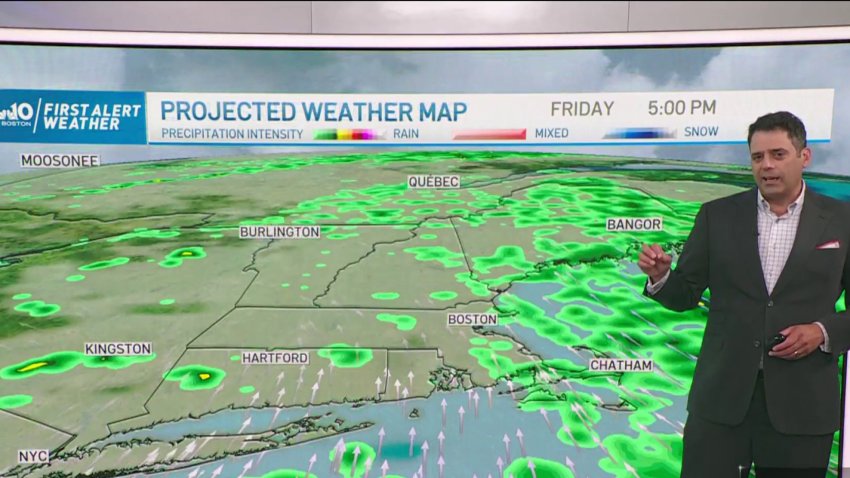
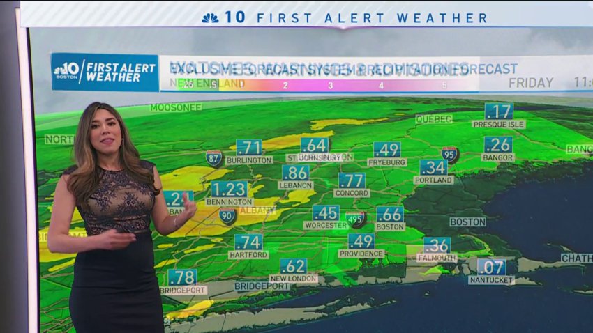
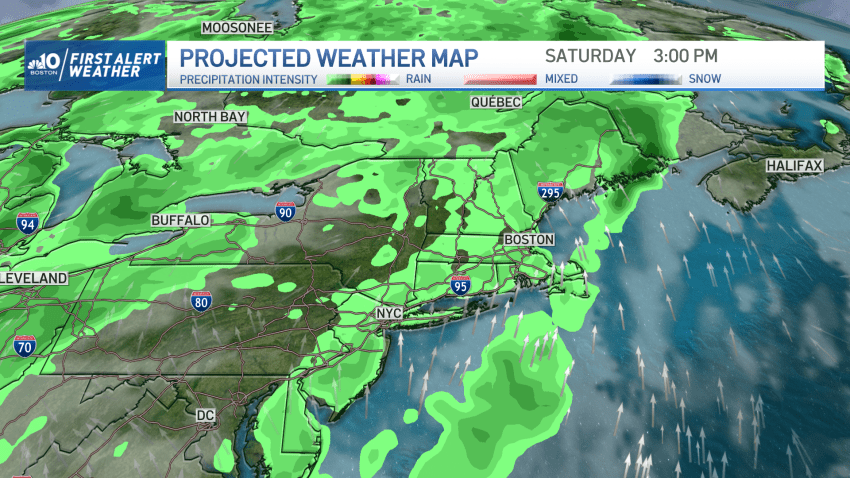
Forecast: Spotty rain and snow storms to cover New England over the weekend
Friday night: Cloudy with a few stray showers or flurries. Areas of fog. Lows in the low 30s. Saturday: Areas of fog then mostly cloudy. Spot shower or flurry north. Highs in the low 40s. Sunday: Rain to snow. Plowable snow in higher elevations. Temps in the 30s.
-
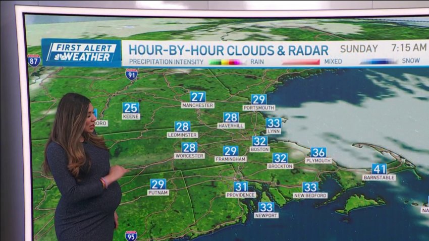
Forecast: Region wakes up to bitter cold
Today: Frosty morning. Highs in the lower to mid-40s, sunny skies. Overnight: Clear & frigid. Dipping to the lower and mid-20s inland, around 30 in Boston. Monday: Frigid start in the 20s inland, around 30 in Boston, highs in the upper 40s, sunny afternoon. Tuesday: Highs in the upper 40s to 50. Variable skies.
-
Perfect weather for Sunday Night Football before thunderstorms return Monday
High pressure will provide us with a beautiful afternoon with plenty of sunshine to go around. Highs Sunday reach the mid to upper 70s along with a wind out of the northwest 7-15 mph. Seas will still be a bit rough in the wake of Lee, so watch for rip currents if you’re headed to the beaches. No weather issues...
-
After Lee, sun and heat returns to New England
The remnants of Lee are long gone – he’s zipping off to the northeast over the Gulf of St. Lawrence and Newfoundland today. Behind the storm, winds have eased and today is going to be a gorgeous day regionwide. After a cool start this morning, we’re set to rebound into the 70s to around 80 with low humidity. Sunshine will…
-
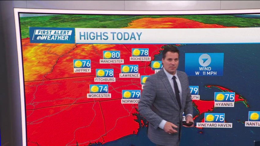
Forecast: Sun and heat returns
Sunday: Sunny and delightful. Highs 75-80. Monday: Mostly cloudy with showers. Highs 65-70.
-

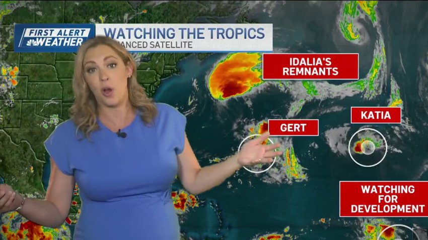
Climate change could bring more storms like Hurricane Lee to New England
When it comes to hurricanes, New England can’t compete with Florida or the Caribbean. But scientists said Friday the arrival of storms like Hurricane Lee this weekend could become more common in the region as the planet warms, including in places such as the Gulf of Maine. Lee remained a Category 1 hurricane late Friday night with sustained winds of 80...
-
Forecast: Scattered showers through first half of week
Overnight: Lows in the upper 60s, cloudy, some fog. Monday: Scattered showers/storms, highs in the upper 70s, humid, mostly cloudy.
-
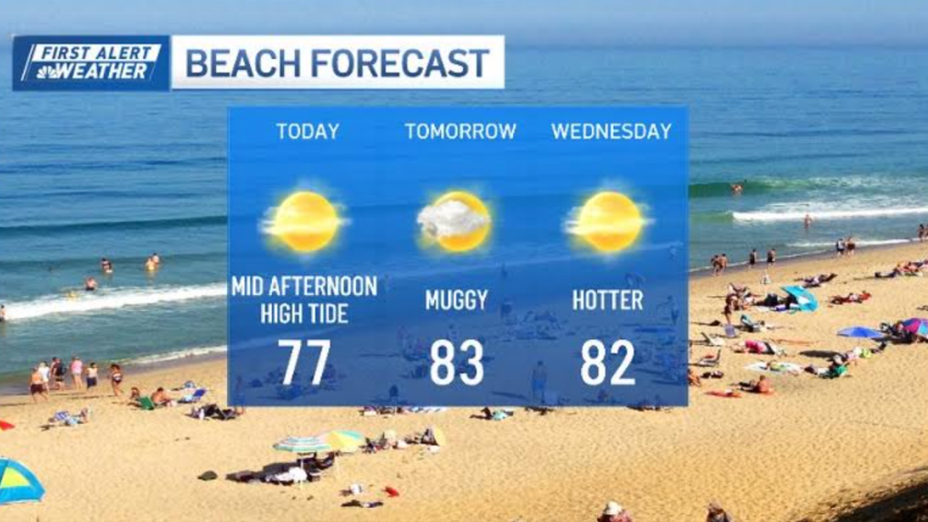
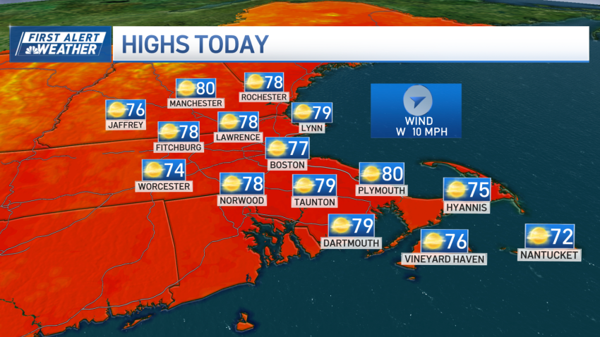
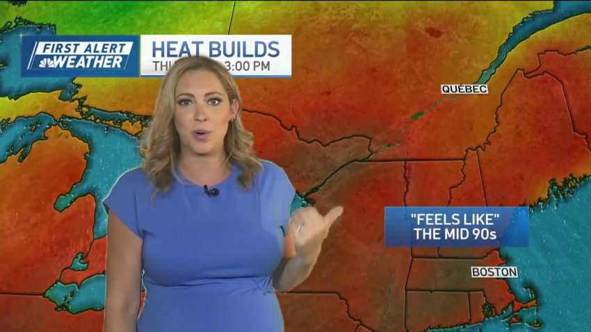
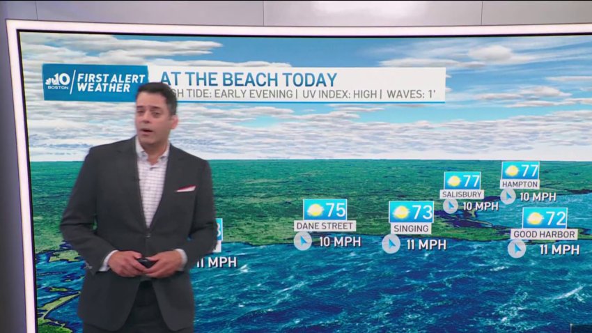
Summer lingers just a bit longer this week
Labor Day brings more heat and humidity to Boston, but it will still be a great day at the beach. The wave heights have lowered and the rip current risk is low. The high tide will be at 3:30 PM. Highs will be in the mid 80s, with upper 80s inland. For the rest of the week ahead, heat will…
-
Forecast: Summer weather stretches through the week
Today: AM patchy fog, PM sun, highs in the upper 80s inland, sea breeze at/near the coasts. Tonight: mild, low in the upper 60s, variable clouds, fog. Tuesday: highs in the lower to mid 80s east, upper 80s to 90 inland, humid.
-
Forecast: Warm & sunny Labor Day
Tonight: Few clouds then developing fog near sunrise at the coast. Lows in the mid to upper 60s. Labor Day: Early fog near the coast, bright afternoon, highs in the low 80s east to upper 80s inland. Tuesday: Mostly sunny, humid. Highs in the upper 80s inland, low 80s at the coast with a sea breeze.
-
Forecast: Plenty of sunshine on Labor Day
Tonight: Few clouds then developing fog near sunrise at the coast. Lows in the mid to upper 60s. Labor Day: Early fog near the coast, bright afternoon, highs in the low 80s east to upper 80s inland.
-
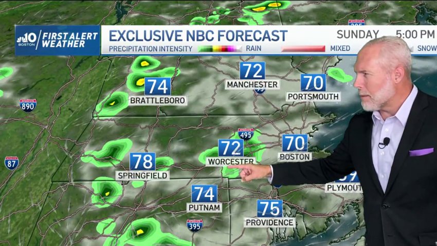
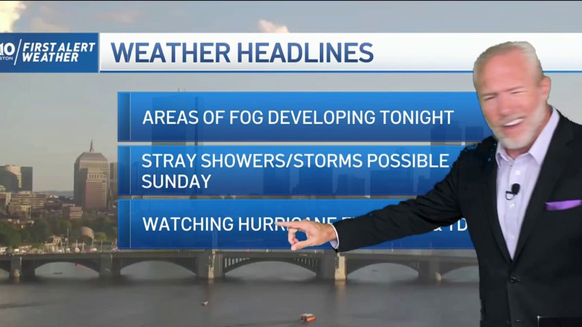
Forecast: Patchy areas of fog and rain
Tonight: Partly to mostly cloudy and mild. Patchy fog possible. Low in the mid 60s. Sunday: Morning clouds then partly cloudy. A few stray showers or storms possible. High in the low to mid 70s. Monday: Partly cloudy. High in the low to mid 70s.
-
Forecast: Stray showers overnight into Sunday
Tonight: Partly to mostly cloudy and mild. Patchy fog possible. Low in the mid 60s. Sunday: Morning clouds then partly cloudy. A few stray showers or storms possible. High in the low to mid 70s. Monday: Partly cloudy. High in the low to mid 70s
-
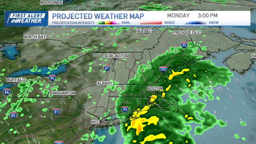
Forecast: Rainy start to the weekend
Today (Thursday): Sun to clouds. Highs 75-80. Overnight Tonight: Light rain arrives. Lows in the 60s, 50s north. Friday: Periodic rain. More humid & breezy. Highs near 70. Saturday: Sun & clouds, scattered showers/thunder. Highs around 80.
-
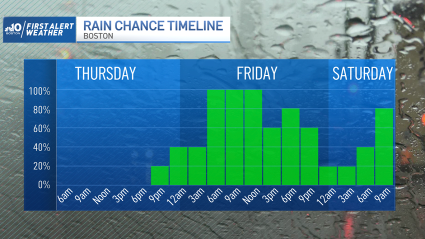
Another round of weekend rain headed our way
As lower dewpoint air remains, we continue to enjoy dry skies and sunshine. Sunny skies will change with the arrival of energy in the atmosphere drawing up rain on Friday. In a similar fashion to Wednesday morning, Thursday morning has temperatures in the upper 50s, to low 60s. The refreshing start to the day ends as clouds pour in midday….
-
Forecast: Weekend rain headed our way
Thursday: AM sun to clouds, evening showers. Highs in the 70s. Friday: Humid with periodic showers and rain. Highs 65-70.
-
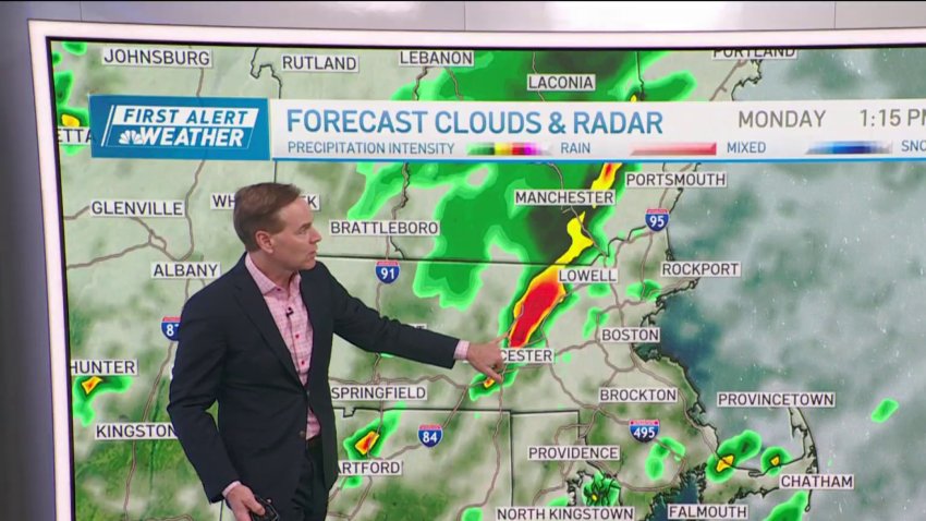
Forecast: Rain returns with possible isolated thunderstorms
Overnight Tonight: Increasing clouds. Lows in the 60s. Monday: Showers arrive mid to late morning. Afternoon and evening downpours, embedded thunder possible. Highs in the 70s. Tuesday: Scattered thunder, isolated damaging storms. Highs around 80.
-
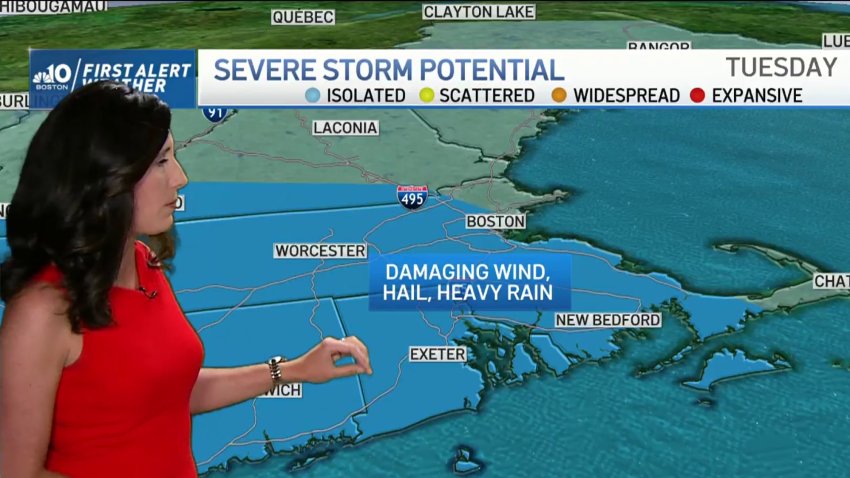
Forecast: Rainy Start to the Week
Overnight Tonight: Increasing clouds. Lows in the 60s. Monday: Showers arrive mid to late morning. Afternoon and evening downpours, embedded thunder possible. Highs in the 70s. Tuesday: Scattered thunder, isolated damaging storms. Highs around 80.
-
FORECAST: Temps reach extreme heat before rain
Today (Wednesday): Sunny, humid, isolated storm late. Highs around 90. Overnight: Mostly cloudy, patchy fog. Lows in the upper 60s. Thursday: Mostly cloudy, scattered pm showers or storms. Highs in the upper 80s. Friday: Scattered showers and strong storms. Highs in the low 80s.
-
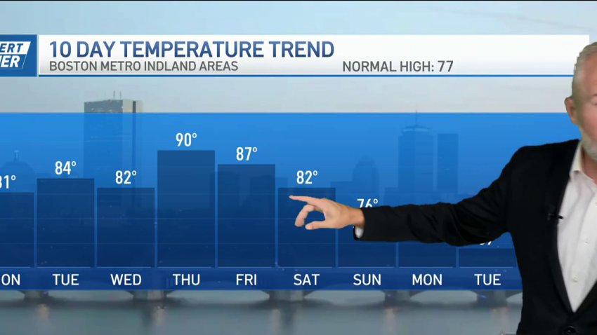
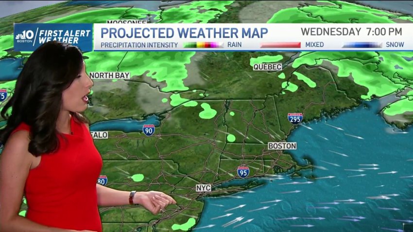
More heavy rain possible this week for flood-hit New England
Scorching heat takes us to the 90s today along with bright skies and high humidity. Isolated downpours and embedded thunder is possible across northern and western New England today. Severe thunderstorm warnings were issued in parts of Maine and western Massachusetts Wednesday afternoon, but they have since expired. Click here to see active weather alerts. More impactful precipitation, however, is…
Trending
