
We had another soggy start to the day as showers spread across much of southern New England overnight. Improving conditions took over Saturday afternoon as much of the rain activity shifted offshore and exited.
The low pressure system south of New England causing the continued rainfall will decrease in coverage, becoming more localized, primarily south to the Massachusetts Turnpike. Cloudy conditions, however, will persist across much of southern New England, resulting in below-normal high temperatures for the day which stay in the low to mid 60s.
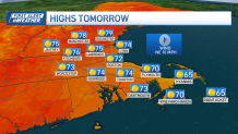
As we move into Sunday, the mid-level surface low-pressure system moves farther away offshore, leading to decreasing clouds and mostly sunny skies by Sunday afternoon. This clearing will allow temperatures to rise back to the 70s, enjoying highs above average, mostly away from the immediate coast.
Get New England news, weather forecasts and entertainment stories to your inbox. Sign up for NECN newsletters.
Influenced by a high pressure system in control, temperatures much of next week will stay above average resulting in pleasant conditions. Monday’s highs will range in the 70s but Tuesday brings even warmer temperatures with highs that climb into the 80s inland north and west in several valleys.
Towards the end of the week, a trough is likely to move into the region late Friday into Saturday, the timing and intensity is still to be pinned down but a frontal system sliding through the region may enhance the chance of rain/thunderstorms.
Temperatures by that time will likely come down to slightly cooler than seasonable during this period.
