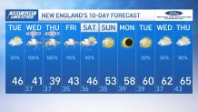
We’re in the calmer and cloudy conditions Tuesday – which will also bring cooler air. While there will be a breeze, it’s a far cry from our gusty and windy week ahead.
High temperatures are near 45 degrees, with onshore flow across the coast. Further inland, we’ll touch the upper 40s.
Light rain and scattered showers pop up for the afternoon and evening across the South Coast of New England, and most of it finishes before midnight.
Timeline, impacts for this week's storm
Get New England news, weather forecasts and entertainment stories to your inbox. Sign up for NECN newsletters.

Through Wednesday morning as the nor’easter reaches our area, we’ll see scattered rain and precipitation as winds pick up along the coast. The steadier rain will be reserved for the afternoon and evening drive.
Thursday morning as the winds change from the north and west, it’s still breezy with gusts between 30 and 45 miles an hour. This is when the storm will have peak intensity and the temperatures dip down to the low 30s into the Worcester Hills and across southern New Hampshire. Rain could mix with and change to snow in these spots, while the rain intensity picks up elsewhere.
Local


Click here for the latest weather alerts.
Gusts along the coast will increase as well. We could see some top 45-50 mph from Cape Ann to Cape Cod and the islands.
All the while, the water will pile up along the coast thanks to the slow movement of the storm and the “fetch” (winds traveling a long distance over the ocean). Although our storm isn’t hitting during the high astronomical tides of the month, the storm surge of 2-3 feet could make up the difference and give us some minor to moderate coastal flooding.
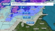
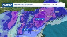
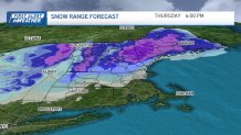
Snowfall maps for Mass., NH and northern New England
The storm begins to weaken by Thursday afternoon, although our best chance at accumulating snow will be long done by then. The greatest accumulations will be across northern Worcester County and throughout southern New Hampshire. Most of northern New England will see even more than that, with isolated spots over a foot!
The storm sits offshore through Friday, but it will be unraveling the whole time. Showers could pepper us into Friday night, but the winds will be lighter and the threat for accumulating snow will diminish.
Warm-up coming next week
The second half of our 10-Day forecast features warmer days ahead with temperatures near 10-15 degrees above normal!