
The strong, high-pressure system that brought us a fine cold weekend, is now pushing offshore and the return flow is warmer and wet and windy.
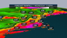
Despite the warmth, it’s not a very nice Monday. Showers become a steady rain from south to north by mid-day, perhaps even becoming heavy at times.
The rainfall amounts of close to an inch combined with melting snowpack could result in some deep puddles, and maybe some street flooding. The flood threat is not only for later Monday, but right through Tuesday as the snow continues to melt despite diminishing showers.
Highs Monday close to 50 degrees south, and in the 40s north. Wind from the south will be increasing gusting past 30 mph near the shore in the afternoon.
Wind from the southwest Monday night could gust past 50 miles an hour from Cape Cod to the coast of Maine. Otherwise, it will be breezy with patchy dense fog away from the coast.
There may be a sunny break Tuesday, so it won’t be as wet. Meanwhile, the temperatures will near 60 degrees in a lot of spots so the snowmelt will continue.
A cold front pushes through Tuesday night and the temperatures will cool down rapidly, enough that rain may change to snow before midnight in western New England and then in the eastern part of the region during the morning commute.
Local


A few inches of snow are possible, especially on untreated surfaces in southern and eastern New England Wednesday through early afternoon, as temperatures hold or even fall from the 30s into the 20s.
It's still early, but it looks like we may have a few inches, and it could be falling for the morning commute in some locations. Either way, we clear out and turn cold again Wednesday night with a refreeze of all those deep puddles and backyard ponds. Low temperature in the teens north 20s south.
Thursday looks sunny and cold. High temperature in the 20s to lower 30s.
Clear and very cold Thursday night, low temperature near 0 degrees, where there's deep snow on the ground. It will be more like 20 degrees near the city in the coast.
Friday looks fair and dry with a temperature in the 30s. Another coastal storm could impact us next weekend, with a potential wintry mix maybe changing over to rain as the storm track is yet to be determined.
Stay tuned to her First Alert 10-Day Forecast for the latest.
