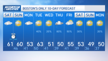
It’s the 6th dry weekend we count since June 1st and Bostonians are making the best out of the good weather.
Highs today are reaching 60 and we’ll do so again tomorrow. Two differences are that more clouds take over this afternoon and our sunset time will change. We’ll be ending DST and we’ll have to set our clocks back an hour before going to bed.
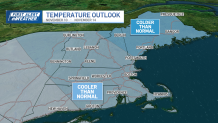
Our high pressure system offshore and a weak cold front moving south through Northern New England is influencing our weather today and in the coming days, bringing a mix of mild temperatures through tomorrow with cloud coverage this evening.
Our winds will stay calm, there will be more sunshine Sunday and highs that will take a chance to rise to near 60. The winds will shift NW tomorrow as a weak short wave is approaching the region.
Get New England news, weather forecasts and entertainment stories to your inbox. Sign up for NECN newsletters.
The cloud coverage will take place in the morning hours as our cold front moves south but skies will gradually move out and the wind will remain NW. Monday will be slightly cooler with a brief round of late showers Monday night into Tuesday morning.
Tuesday afternoon will bring milder temperatures, our highs will top out around the low 60s for which we’ll only see a few showers left SE before improving conditions come along Wednesday with the exception of cooler air.
Local

Wednesday will bring our highs back to the low 50s and we may see some rain Wednesday night into Friday AM. The potential for snow and ice in higher elevations may take place Wednesday night into early Thursday.
Our following weekend will trend cooler with temperatures dipping to the lower 50s and upper 40s by the latter half.