
One storm system is about to exit New England, and we'll get a brief break before another storm system makes it back into the area.
We could still see a few passing showers Friday night into Saturday morning, but most of the day will be dry, with a cloudy sky. There could be some areas of fog as well Friday night through Saturday morning. Some of the fog could reduce visibility below half a mile.
Temperatures across New England are in the low 30s to the north and as cool as the mid-20s across northern parts of Maine right now. Down to the south, we're in the mid-30s to around 40 -- still well above freezing, so even with that next system coming in, the overall impacts from a wintry weather standpoint will likely be pretty minimal.
To the north, we have a winter weather advisory in effect across parts of Vermont, New Hampshire and into Maine. That's that departing storm system, and now showers will exit southern parts of New England and the snow will eventually move out as well.
Get New England news, weather forecasts and entertainment stories to your inbox. Sign up for NECN newsletters.
We've got a more active weather pattern to the west-southwest. That next storm system is moving across parts of the southern U.S. and across the Gulf of Mexico, and that's going to give us our next chance for precipitation as we go into Sunday and Monday. But those southern tracks usually bring in a little nose of warmer air with it. That reduces the chance of wintry precipitation.
So we're dry for Saturday, but Sunday and Monday that next storm system is coming in.
Track this weekend's storm with live radar
Local


Temperature-wise, we're going to go from the upper 30s to around 40 for the next couple days, cooling back down to around 30 by Tuesday. And then we'll come right back up to the mid-30s, which is close to what we normally have at this time of year.
As we head through the remainder of the day on Friday, we'll see a few scattered showers, but there's not a whole lot left as we head to 5 p.m. We'll be in the mid-30s and upper 30s, with a few spots in the low 40s for Friday afternoon.
Friday night into early Saturday, by midnight we're looking at a couple showers forming. Through morning we may see a few scattered showers, a few snowflakes, but nothing impactful, with temperatures in the low- to mid-30s.
Saturday afternoon will be in the mid-30s to upper 30s, with plenty of clouds. We're not going to see a whole lot of sunshine Saturday or Sunday either.
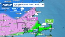
Late Saturday night into early Sunday we start to see a few ribbons of some of that moisture coming in. The first few morning hours of Sunday, especially across the western half of the state, that's where there's a better chance for some snow mixing with rain.
Temperatures will generally be around freezing or above. If we do see warmer weather snow, unless it's coming down really heavy it probably won't have a big impact on the roads. By noon, there will still be showers to the south, with snow to the north, and the snow band pushes a little further north. Temperatures will be in the mid- to upper 30s, with a high temperature near 40.
Snowstorm weather forecast for Boston
Our eyes then turn to the storm system headed our way late Saturday night, through Sunday, and continuing on Monday.
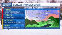
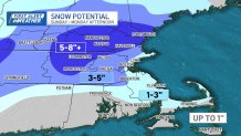
Right now, our greatest chance for more substantial accumulation (6 inches or so) is in the elevated terrain of central Massachusetts and cities and towns northwest of Interstate 495 into southern New Hampshire. Along the coast, we’ll start as rain and then transition to snow at the end.
The greater Boston metro area will likely be on the lower end of the snow range (2-4 inches), but we will also have to factor in some gusty winds that are expected to develop as the low moves east. Given the timing of the snow, it could slow down the Monday morning commute considerably.
Wind will increase to 15 to 25 mph for sustained wind speeds, primarily at the coast. We could see speeds top 45 mph on Cape Cod and the Islands throughout Monday.
Check back for updates on this developing storm system.
