New England gets all kinds of weather. If you like summertime, but not the sticky weather, this is the finest kind.
The extreme heat in the middle of the nation has pushed northward into Canada, now is traveling east, and then south into New England.
When the air travels in that path, most of the moisture is wrung out in thunderstorms more than 1000 miles away.
The result is fair weather with warm nights, and comfortably cool days for us.
For this afternoon we are on the edge of a weather system sliding by off to our south, so skies are somewhat cloudy in Connecticut, with increasing sunshine as you move north and east. Temperatures this afternoon are 80 to 85 inland, mid-70s by the shore with light variable wind and local seabreeze.
Skies are mostly clear tonight, with a waxing Strawberry Moon, temperatures fall through the 60s after sunset into the 50s and even some 40s by sunrise tomorrow.
The old low-pressure system that has been on the coast of south eastern Canada is backing up a little bit, pushing some cooler air in for our Friday.
Local
We should have more sunshine than clouds, a sprinkle is possible, with high temperatures Friday in the 70s east, 80s west.
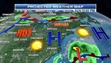
The weekend is looking good in New England, but the weather map is most interesting.
Record-breaking heat in the middle of the nation will be pushing toward the Great Lakes states.
A front off the east coast of the United States, south of New England, will generate a powerful ocean storm.
It does not look like a tropical storm initially, but could evolve into something that is tropical off the mid-Atlantic states by Sunday and Monday.

The shape of the jetstream is very interesting, that storm may actually move toward the west, and even northwest, toward our south coast.
Though it looks like the storm should stay well off shore, we will at least see high clouds on our southern horizon by late in the weekend.
There's also an active the storm track across Canada.
Here in New England we are positioned to between that ocean storm, and the next front in northern Ontario.
That means we will have mostly a wind from the west pushing temperatures close to 90 by Sunday and Monday.
The front in Canada pushes into New England on Tuesday, that is when we turn more humid with thunderstorms arriving from north to south.
The temperature is also near 90 on Tuesday, the first full day of summer, will be hot and humid with scattered storms.
What happens the second half of next week looks interesting also, we may have that front stalling in New England with beneficial rains the second half of the week.
We probably stay a little bit warmer than normal, and more humid, with the threat for showers and storms in days 7-10.
We will be fine tuning that forecast as it gets closer.


