Wow! What a difference the drop in humidity has made.
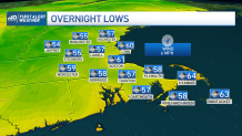
After the passage of last night’s cold front, temperatures have dropped to the 70s and our dew points took a dip to the lower and mid-50s, which makes it so refreshing.
Windows may be opened again, sunglasses will be needed and if hiking high in the mountains, take the long sleeves as temperatures feel cooler thanks to the northwest wind coming in.
Get New England news, weather forecasts and entertainment stories to your inbox. Sign up for NECN newsletters.
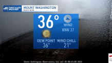
Out in Mt. Washington this morning, wind chills were down in the 20s.
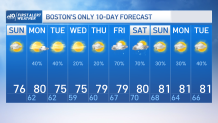
Finally, our page flip keeps the chance of rain low for a few days this week. While Monday does open the gate to some showers/storms erupting in northern New England, the push to the south takes longer, so the evening will welcome a few scattered showers, an isolated storm or two is possible with high temperatures in the low 80s. Otherwise, it’s mostly dry for the Cape & Islands.
Tuesday-Thursday will be mostly dry, sunny and cool; temperatures will stay in the 70s along dry air. Friday-Saturday will once again open the gates to rain & storms…
See a full list of severe weather alerts here.