
-
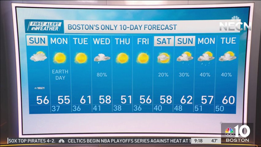
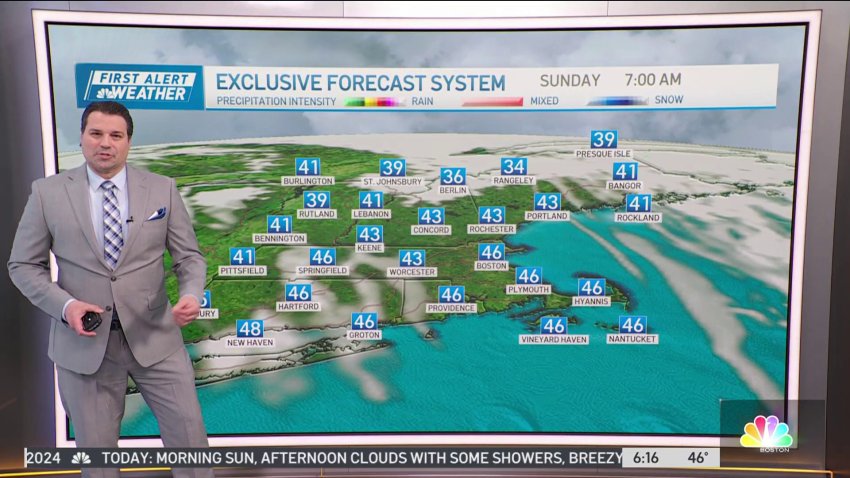
Clouds dim otherwise Sunny Sunday afternoon
Today (Sunday): Morning sunshine, afternoon clouds dim out the sun, breezy. Highs upper 50s. Overnight Tonight: Decreasing clouds, chilly, patchy frost. Lows in the 30s. Monday: A frosty start, mostly sunny. Highs upper 50s.
-
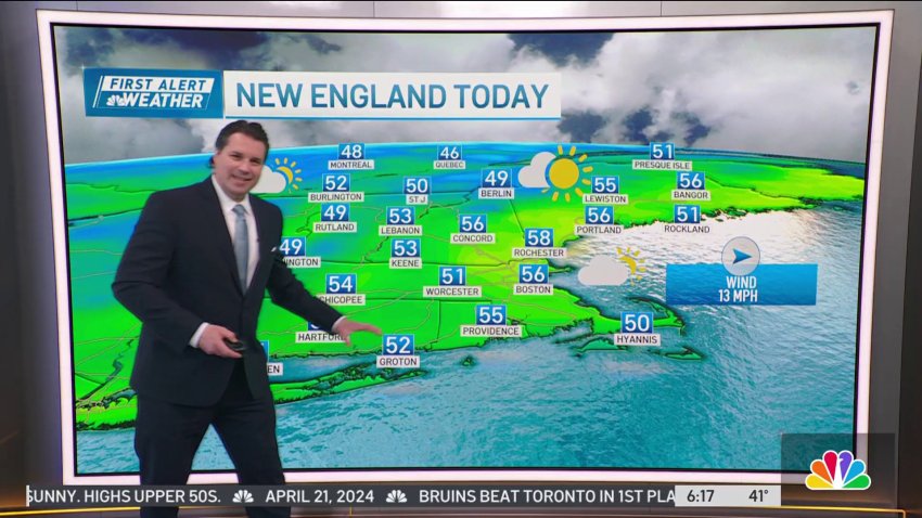
Sunny afternoon leads into chilly Sunday night
Today (Sunday): Morning sunshine, afternoon clouds dim out the sun, breezy. Highs upper 50s. Overnight Tonight: Decreasing clouds, chilly, patchy frost. Lows in the 30s. Monday: A frosty start, mostly sunny. Highs upper 50s.
-
Rain continues on Saturday before sunny Sunday
Today (Saturday): Showers this morning lingering into the early afternoon coast, few late day showers. Highs low to mid 60s. Overnight Tonight: Decreasing clouds, breezy. Lows upper 30s to low 40s. Sunday: Mostly sunny, breezy. Highs upper 50s to low 60s.
-
Rainy Saturday to kick off weekend
Today (Saturday): Showers this morning lingering into the early afternoon coast, few late day showers. Highs low to mid 60s. Overnight Tonight: Decreasing clouds, breezy. Lows upper 30s to low 40s. Sunday: Mostly sunny, breezy. Highs upper 50s to low 60s.
-
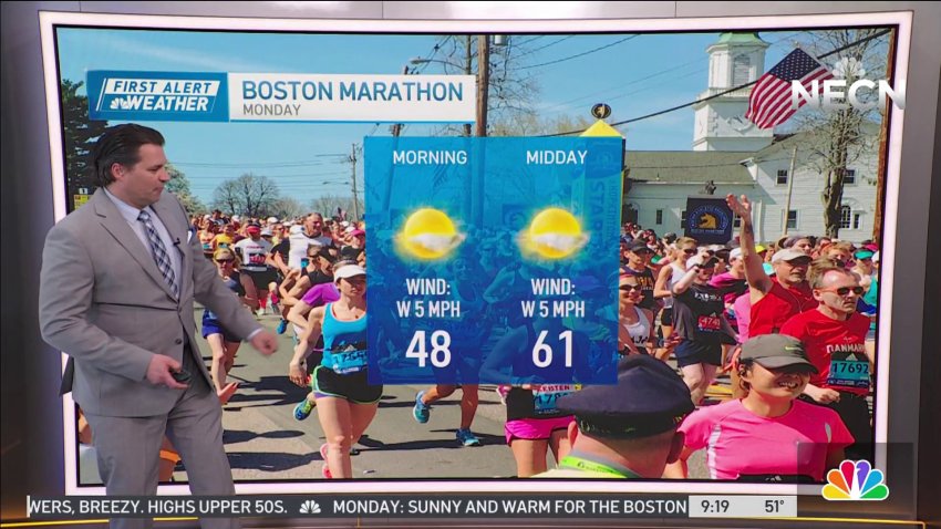
Pleasant Marathon Monday after Sunday night rain
Today: Morning sunshine, afternoon clouds, mid to late afternoon showers, breezy. Highs upper 50s. Overnight Tonight: Showers and storms early, clearing late. Lows low to mid 40s. Monday: A blend of clouds and sun, isolated PM sprinkle or shower. Highs low to mid 60s.
-
Sunny morning before afternoon showers on Sunday
Today: Morning sunshine, afternoon clouds, mid to late afternoon showers, breezy. Highs upper 50s. Overnight Tonight: Showers and storms early, clearing late. Lows low to mid 40s. Monday: A blend of clouds and sun, isolated PM sprinkle or shower. Highs low to mid 60s.
-
Cloudy with some isolated showers on Saturday in New England
Today: Clouds and sun, breezy, isolated showers. Highs mid 50s. Overnight Tonight: Mostly cloudy, less wind. Lows low 40s. Sunday: Morning sun, afternoon clouds with some showers, breezy. Highs upper 50s.
-
Cloudy Saturday with some isolated showers
Today: Clouds and sun, breezy, isolated showers. Highs mid 50s. Overnight Tonight: Mostly cloudy, less wind. Lows low 40s. Sunday: Morning sun, afternoon clouds with some showers, breezy. Highs upper 50s.
-
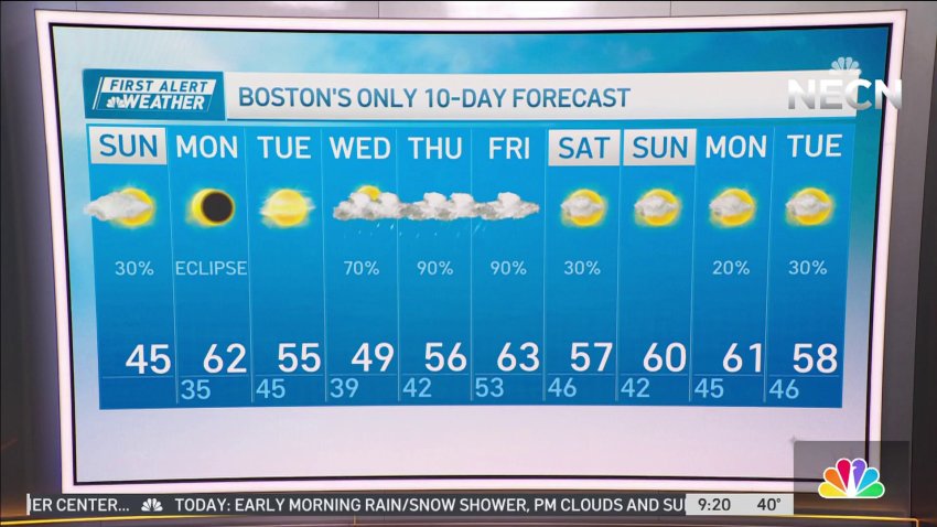
Clearer skies expected for solar eclipse on Monday
Today: Early morning rain/snow shower, PM clouds and sun, breezy. Highs mid 40s Overnight Tonight: Decreasing clouds, chilly. Lows mid 30s. Monday: AM sunshine, some high, thin afternoon clouds. Highs low 60s.
-
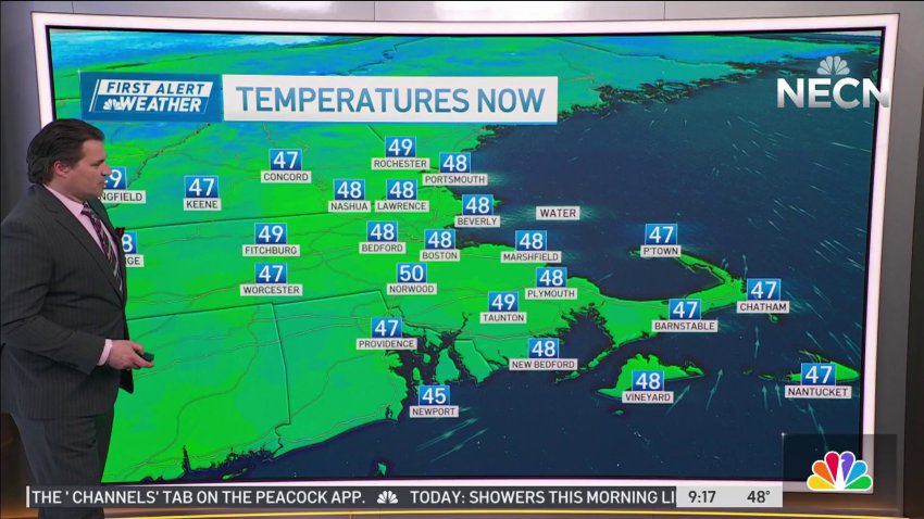
Chilly and breezy Sunday morning
Today: Early morning rain/snow shower, PM clouds and sun, breezy. Highs mid 40s Overnight Tonight: Decreasing clouds, chilly. Lows mid 30s. Monday: AM sunshine, some high, thin afternoon clouds. Highs low 60s.
-
Cloudy with a bit of rain on Saturday
Today: Mostly cloudy, breezy, few rain/snow showers coast. Highs low to mid 40s. Overnight Tonight: Mostly cloudy, breezy with scattered rain/snow showers coast. Lows mid 30s. Sunday: Clouds and sun, breezy, a morning snow/rain shower coast. Highs low to mid 40s. Cape Cod Radio Forecast: Today: Overcast, breezy with scattered rain showers. Highs low...
-
Sunny Easter before possible mid-week storm
Today: Morning clouds, isolated sprinkle/shower, some afternoon sunshine. Highs in the 50s. Overnight Tonight: Partly cloudy, chilly. Lows mid to upper 30s. Monday: Clouds and sun, light onshore breeze. Highs low to mid 50s.
-
Sunny Easter Sunday after cloudy morning
Today: Morning clouds, isolated sprinkle/shower, some afternoon sunshine. Highs in the 50s. Overnight Tonight: Partly cloudy, chilly. Lows mid to upper 30s. Monday: Clouds and sun, light onshore breeze. Highs low to mid 50s.
-
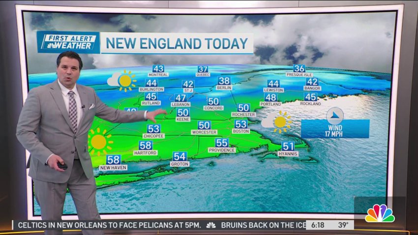
Sunny and breezy Saturday in New England
Today: Breezy early, sunshine with a few PM clouds, less wind. Highs in the 50s. Overnight Tonight: Partly cloudy, chilly. Lows mid to upper 30s. Sunday: Sunshine and clouds. Highs low to mid 50s.
-
Breezy Saturday in New England
Today: Breezy early, sunshine with a few PM clouds, less wind. Highs in the 50s. Overnight Tonight: Partly cloudy, chilly. Lows mid to upper 30s. Sunday: Sunshine and clouds. Highs low to mid 50s.
-
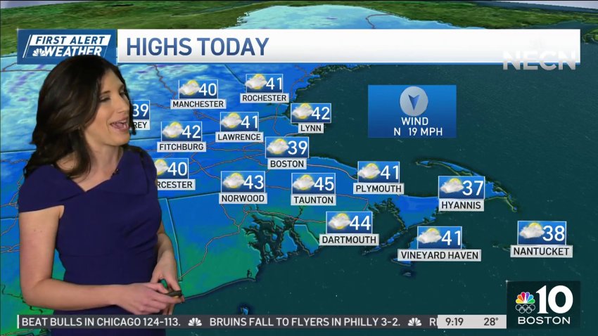
Blustery Sunday as region dries up after storm
Today: Sun and some high, thin clouds. Blustery. High around 40, wind chill near 30. Tonight: Mostly clear to partly cloudy. Low in the 20s in the suburbs, 30s on Cape Cod. Monday: Sun and a few clouds. Breezy, gusts to 30 mph, 40 mph on Cape Cod. Highs around 40, wind chill near 30.
-
Chilly Sunday after storm pummels the region
Today: Sun and some high, thin clouds. Blustery. High around 40, wind chill near 30. Tonight: Mostly clear to partly cloudy. Low in the 20s in the suburbs, 30s on Cape Cod. Monday: Sun and a few clouds. Breezy, gusts to 30 mph, 40 mph on Cape Cod. Highs around 40, wind chill near 30.
-
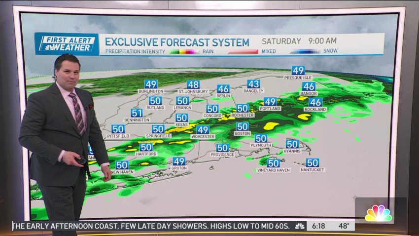
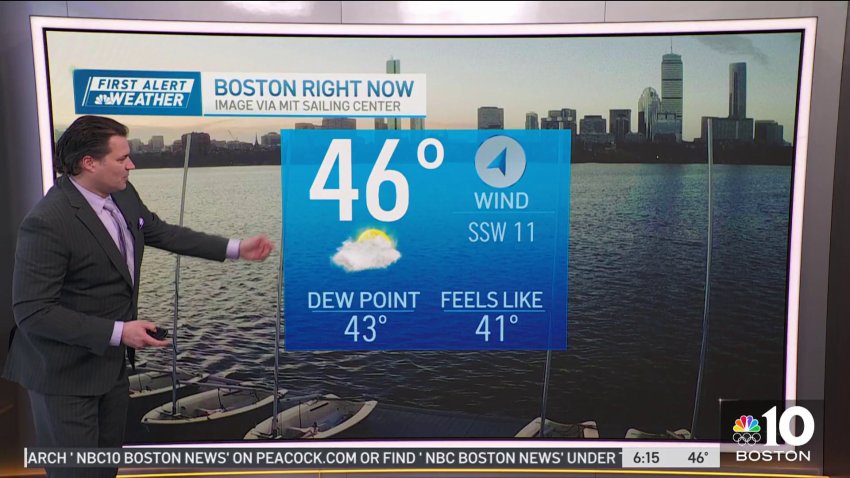
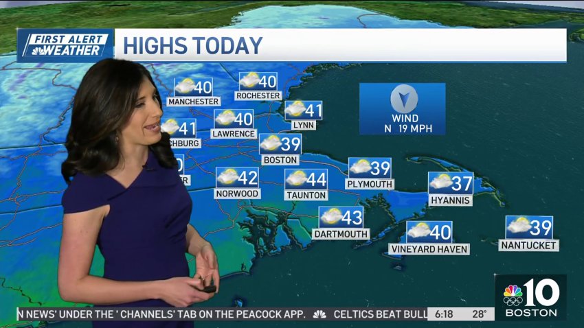
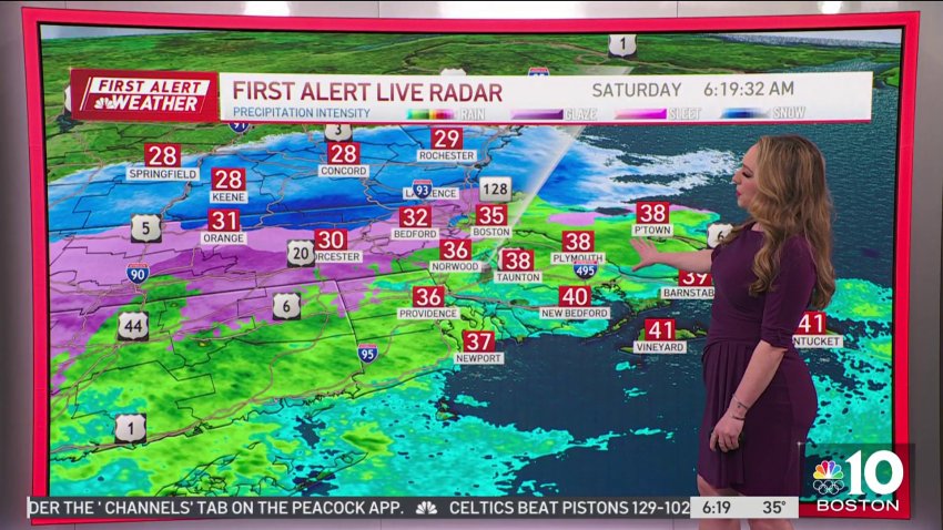
Rainy Saturday as storm passes through the region
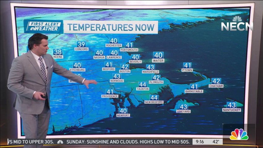
Some colder holdouts in Northern Mass and Southern New Hampshire are over to ice this morning, but even here, the temps will gradually warm as we transition to rain.
-
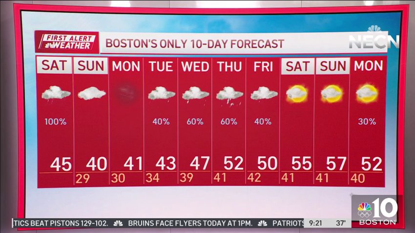
Heavy rain expected in parts of New England on Saturday
Our storm started as snow – with a coating to as much as an inch in spots overnight – but the second act promises to deliver in the rain department.
-
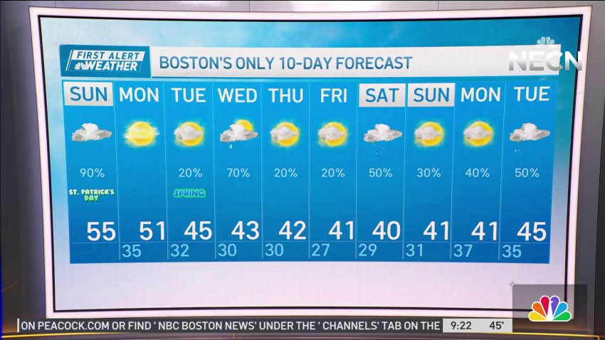
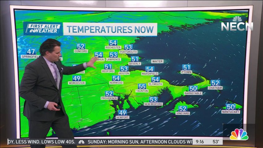
Week ahead stays cool after St. Patrick's Day
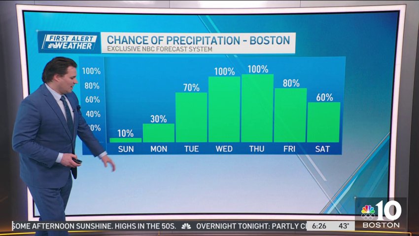
Today (Sunday): AM showers, decreasing afternoon clouds, breezy, isolated shower/sprinkle. Highs in the 50s. Overnight Tonight: Few clouds, breezy, and chilly. Lows low to mid 30s. Monday: AM sunshine, some afternoon clouds, breezy. Highs upper 40s to low 50s.
Trending
