The sun may be out, but the possibility of a windy wintry mix looms over New England's Thanksgiving holiday travel this week.
A powerful high-pressure system anchored over Quebec is steering unseasonably chilly air into New England. This setup guarantees Monday will dominated by sunshine, but the mercury struggles, with highs peaking in the upper 30s to lower 40s, regionwide.
The high terrain faces an extra chill, barely reaching the mid-30s – and a persistent northerly wind adds to the brisk conditions for all of us, creating wind chill values ranging from the 20s to the lower 30s in the afternoon.
While southern New England enjoys clear skies, Cape Cod and Nantucket will continue to see occasional ocean-effect clouds due to the same northerly flow of cool air over a relatively warmer ocean, perhaps dropping a sprinkle or flurry on the Outer Cape from time to time.
Get New England news, weather forecasts and entertainment stories to your inbox. Sign up for NECN newsletters.
As night falls and the high-pressure system crests over New England, a clear sky and light wind will set the stage for optimal radiational cooling. Lows plummet into the teens, possibly single digits in the coldest valleys of the North Country, with urban areas like Boston and parts of the outer Cape and Nantucket remaining somewhat milder, with lows between 25 to 30 degrees.
Tuesday starts sunny but transitions into increasing clouds in the afternoon ahead of a low-pressure system moving into the eastern Great Lakes en route to New England, where a new storm center will develop along the Mid-Atlantic coast and track over southern New England Wednesday.
Coming off a cool Tuesday with highs in the 30s north and 40s south, the arrival of precipitation Tuesday evening from 7 to 11 p.m., west to east, across most of New England except a later arrival in Maine, will be marked by a burst of snow away from the coastal plain.
After one to three inches of snow deep inland across central and western Massachusetts to northwest Connecticut, temperatures will warm for a change to rain predawn Wednesday, while the rain/snow line races north through the New Hampshire Lakes Wednesday morning but may stall at the mountains, affording as much as half a foot of snow for some of the North Country!
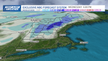
Admittedly, the forecast is very marginal with regard to temperature, so even a slight change would limit these forecast amounts. Regardless, the rain elsewhere will cause road and air travel delays in New England Wednesday morning, with increasing southeast wind gusts to 55 mph on Cape Cod and over 40 mph at the coast exacerbating the travel headaches and chance of delays at eastern New England airports from T.F. Green in Providence to Boston Logan to the Portland Jetport.
Thanksgiving ushers in a quieter period with dry, cool, and breezy conditions for football games and road races ahead of a cool Friday and Saturday, though next weekend brings a fast-moving disturbance that may deliver snow showers on Saturday or Sunday – at this point, Saturday looks like the more likely day.