
Hope you caught your breath. The next storm is breathing down our neck, but this time it's not all about the snow.
That's not to say we won't see any. A coating for some, 1 to 2 inches and 2 to 4 inches as we move up in elevation through Worcester County. This, like a vast majority of our snowpack, will be washed away with the heavy rain and mild air inbound overnight.
How much will it snow in Massachusetts, NH?

Get New England news, weather forecasts and entertainment stories to your inbox. Sign up for NECN newsletters.
Initially, our snow will absorb the rain like a sponge. As the snow compacts and saturates, it will become "ripe" and start shedding its water. There is at least one inch of water already locked in the snow, so with at least two inches of rain Tuesday night, we will see three inches of "liquid equivalent" from snowmelt and rain.
If you understood all that, great. You get the gold star. If you didn't, then I'll cut to the chase. There will be plenty of flooding across the area into Wednesday morning. Larger stem rivers may take until Thursday to see significant rises, however.
Heavy rain, high winds could cause power outages
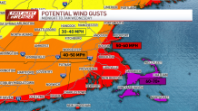
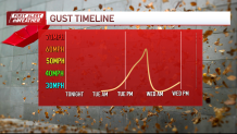
Winds are another matter. Most of us will see gusts in the 40 to 50 miles per hour range. The Capes and Islands see gusts close to 60 or 70. This will be from the southeast, and likely cause thousands to lose power into Wednesday morning. The wind will be particularly fierce just as the most intense rain moves through from 3-5 a.m.
Like many events of this type, the ramp down will be swift. By 5-6 a.m. the rain will push off, the winds will drop significantly, and the sun will poke out around sunrise. Snowmelt will continue, however, and the water will still be pooling and moving through the watersheds.
Be alert for road closures and detours on the ride to work/school. Water along the coast will be rising, too, thanks to the strong south/southeast winds. Minor coastal flooding is possible in Buzzards Bay and in isolated spots elsewhere.
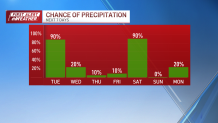
We'll take a break for a couple of days, then watch another super-soaker of a storm move through on Saturday.
Ain't winter grand?


