
The storm center that strengthened east of New England and moved into the Maine coast delivered a soaking rain to much of northern New England during the overnight Wednesday night into Thursday morning.
As the showers attempted to push south, though, they met incoming dry air, pulled from the eastern Great Lakes in the storm’s counter-clockwise flow of air and into southern New England under the belly of the storm.
The drier air not only is eating away at showers Thursday morning, but will break apart clouds in the southern half of New England for emerging sun with westerly gusts to 35 mph that will also elevate brush fire danger Thursday afternoon.
Get New England news, weather forecasts and entertainment stories to your inbox. Sign up for NECN newsletters.
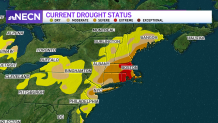
Of course, the absence of significant rain in southern New England means no easing of the extreme drought condition in this week’s Thursday morning drought monitor issuance from the university/government consortium that updates the product weekly, in fact, extreme drought has expanded west into north-central Massachusetts, Rhode Island and eastern Connecticut, with severe drought expanding into the Berkshires and northern Connecticut.
In northern New England, the drier air arriving Thursday doesn’t have such a direct route, so showers will be slower to disintegrate, but will slowly dry up Thursday afternoon. That allows for partial clearing overnight Thursday night, but perhaps not enough to spot a weak Northern Lights event in the northern sky, the product of a coronal mass ejection from the sun a couple of days ago.

Further south, the sky will be clearer though the chance of Northern Lights is less, though the clearing sky and dry air will afford a cool night with low temperatures in the 50s for many suburban locales. The cool and crisp start Friday will have little impact on warming. Dry air cools quickly under a clear sky at night, but also warms quickly when sun is added, and Friday brings plenty of sun along with a wind over the land, not the ocean, meaning temperatures will quickly rise through the 80s to near 90 degrees in southern New England and squarely into the 80s north.

Humidity will remain relatively low in the coming days, ensuring even increasing heat will be fairly comfortable, regionwide, with dew point temperatures climbing enough on Cape Cod for a humid feeling Saturday, but holding off until Sunday for the rest of New England. Once the humidity returns, the chance of showers follows from later Monday onward into midweek next week, though it remains to be determined just how much rain would actually fall, as the showers may remain scattered unless a small area of low pressure can develop to help focus them. Regardless, dry weather is likely to return for the latter half of next week while temperatures remain above average through the end of the First Alert 10-day forecast.
