
A few damp days of weather start the week in New England, though each day won’t be equally wet.
The wettest day comes Monday, with an organizing plume of moisture over the Gulf Stream, east of the Atlantic Seaboard, trucking north and set to deliver downpours to New England through the evening. The rain won’t be even-handed, with communities that line up under repeated downpours lifting from south to north picking up nearly two inches of rain, while most communities see less than an inch.
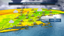
Nonetheless, showers, periodic rain, downpours and pockets of locally dense fog setting up on a northeast wind will be the dominant features through Monday evening, with temperatures climbing to near 60 degrees and a slightly humid feeling on Cape Cod and the Islands by nightfall.
Get New England news, weather forecasts and entertainment stories to your inbox. Sign up for NECN newsletters.
Showers will tend to taper overnight Monday, though pockets of dense fog will persist into Tuesday morning, with Tuesday seeing lots of clouds, lots of drizzle and occasional showers that will mostly pass lightly through from time to time.
The humid feeling will expand northwest for much of southern New England Tuesday with a southeast breeze bumping high temperatures into the 60s, then slightly cooler with meatier showers Wednesday as winds turn from the northeast once again.
By Thursday, New England weather turns a corner – sunshine returns and the air dries out with a one day bonus of mild temperatures near 70 degrees before a push of cooler Canadian air arrives for Friday through the weekend. Another chance of showers returns to the forecast either very late Sunday or Monday into early next week and we’ll keep an eye on that in our exclusive First Alert 10-day forecast.
