
Major Hurricane Lee continues to remain in rare company as a major Category 4 hurricane. Friday morning, its winds were 165 mph. While we may have seen the storm at its maximum intensity, it will remain a major hurricane for several days.
Lee marks the third Category 4 hurricane of the 2023 Atlantic season. Both Hurricanes Idalia and Franklin were Category 4 at one point during their lifespan. Despite a small drop in the storm’s winds, the storm remains powerful.

Between Wednesday and Thursday, the storm underwent rapid intensification twice times over. Rapid intensification refers to a storm’s windspeed increasing by 35 mph in 24 hours. Hurricane Lee intensified by 80 mph in that time span. Only six other hurricanes have accomplished that feat: Wilma (2005), Felix (2007), Ike (2008), Matthew (2016), Maria (2017) and Eta (2020).
Get New England news, weather forecasts and entertainment stories to your inbox. Sign up for NECN newsletters.
Lee will not impact land for the next several days, which is certainly good news. However, land interaction can serve another purpose and help shear the storm apart. There’s less friction over the ocean and it keeps the storm intact.
In the short term, Hurricane Lee moves due north of Bermuda, still as a major Category 4 hurricane. Its forward motion will slow over the weekend. It will still be over an abnormally warm ocean too, so that will allow the storm to maintain its strength.
Most long-range models keep Hurricane Lee over the ocean, and doesn’t make a landfall. Swells will impact northeastern Florida and southeastern Georgia this weekend and early next week. And it’s very likely New England sees similar coastal impacts too.
Weather Stories

Beyond that, it’s far too soon to say with certainty to what extent direct impacts, if any, to the New England coast will be.
We are watching the storm slow down considerably over the southwestern Atlantic, which will mean multiple things in the coming days.

I do believe if—and that’s a big if—we were to get substantial impacts, this buys us time to prepare. We’re in the peak of hurricane season this week, so a firm plan of action for island and coastal communities should well be established at this point. This is the ready stage…of ready, set, go.
The second thing we will see play out as the storm slows, is the turn northward. That turn northward will be generated by upper-level wind energy. The storm will still be over the Caribbean and southwestern Atlantic even by next Tuesday, so time will be in our favor to get other steering parameters in the region.
This can be likened to a football team’s offensive depth chart. We know we have several starting quarterbacks who have both gotten QB1 reps…we’ve got three or four willing and able wide receivers and tight ends…but who starts on gameday will depend on how the week goes with practice, if everyone stays injury-free.
What will guide the offense, or in this case our storm, is an area of high pressure over Bermuda and an incoming area of low pressure embedded in the upper jet stream. How strong, or weak, these features are will work in tandem to bring Lee northward.
Scenario 1
The current path and model consensus has the storm splitting the uprights, and going between Bermuda and the East Coast of the US. Ultimately this wouldn’t be a bad thing for New England. We’d likely get enough wind energy to bring strong swells and rip currents, but it’s fairly limited to that, similar to how Idalia churned up coastal waters of New England.
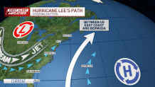
Scenario 2
This would be a better setup for the East Coast. A stronger, and larger, area of low pressure would drive the jet east. That would act as a wall and force Lee, in whatever form it's in, to the east, lessening the blow.
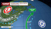
Scenario 3
A stronger Bermuda high pressure system would do the inverse, and guide Lee more westward to the New England coast. While not likely, it’s still a very plausible option. This still doesn’t yield a direct hit. The area of high pressure would need to be persistent in maintaining its large form, or else Lee would have open room to then wobble back west.
Ultimately movement of these storms is like steering a large ship. Most of these turns are so subtle, they aren’t even realized until after they’ve already happened.
We are at the statistical peak of hurricane season, and the season is far from over. The First Alert weather team will continue to monitor this storm and any other tropical threat as they develop.
