Get ready for a bit of a shock to the system.
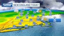
Mild and breezy conditions are expected in New England Tuesday as low pressure tracks north of the region. The area will reside in warm air through much of the day, with a southwest breeze gusting as high as 35 mph at times near the South Coast and steady at 10-20 mph for many others.
A cold front making steady progress from northwest to southeast across New England Tuesday will not only shift the wind to blow from the west and northwest by the end of the day but will also revive a few new scattered showers as it crosses the region.
Get New England news, weather forecasts and entertainment stories to your inbox. Sign up for NECN newsletters.
In central and northern Maine, the showers may even produce some graupel – soft snow pellets – or small hail as they track through the Mahoosuc Region and the Crown of Maine.
Elsewhere, scattered showers that briefly pass through communities from northwest to southeast between early afternoon and early evening, respectively, may contain some embedded downpours, owing to the difference between relatively warm air at ground level and increasingly cold air high in the sky.
The passage of the cold front will mean a big change in air – from highs in the middle and upper 60s in central and southern New England by day to overnight lows some 30 degrees colder, with an overnight wind chill dipping into the 20s as the new, west-northwest wind gusts up to 40 mph in the higher terrain.
Wednesday sees decidedly colder air, with daytime highs only in the 40s and wind chill values in the 30s for most of the day, even under sunshine (except for lingering northern mountain clouds and flurries), with increasing clouds late in the day into the evening ahead of the next disturbance, approaching from the west.
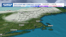
That next disturbance will push our next round of precipitation into New England predawn Thursday, likely to fall as a combination of rain and snow, with flakes mixing in even in southern New England early Thursday!
Temperatures are likely to be warm enough to preclude significant impact in southern New England, though we continue to expect a coating to an inch of accumulation, particularly on grassy surfaces, with northward and westward extent, and with elevation, where some Thursday morning slick spots can’t be ruled out from western and northern Worcester County points north and west.
By Friday, the chance of showers drops dramatically for most of New England, though clouds should outweigh sun considerably over the day with high temperatures not far from 50 degrees, and while fair weather is expected for the weekend, little change in temperature is foreseen as the jet stream remains “zonal” – or flat-flowing – over the Northeast, precluding any big pushes of warmth or substantial chill through the weekend into early next week.
From this early juncture, it appears as though cool temperatures should moderate slowly but steadily next week, with little in the way of substantial weather-makers for New England.