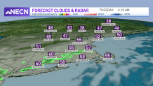
A refreshing airmass has settled into New England after storms and a cold front pushed through yesterday. The humidity is much lower today and highs will be more seasonable in the upper 60s at the coast and low 70s inland.
Onshore winds will keep it cool and breezy at the beaches, so take a jacket if you’re heading out to the coast. Some high level clouds move through from time to time, but they won’t block the sun all day.
Tonight our lows drop to the 40s and 50s south, but in the 30s far north. A frost advisory is actually in effect for far northern Maine as temps will be in the low 30s, which is pretty late in the season. A wave of rain may develop along the south coast overnight tonight into tomorrow morning, then tomorrow we’re dry all afternoon.
Get New England news, weather forecasts and entertainment stories to your inbox. Sign up for NECN newsletters.
Highs tomorrow will be in the 60s to low 70s across the northeast with plenty of sun. Sea breezes at the coast develop again and keep temps in the low 60s there. The next few overnights will be milder in the 40s, with clouds rolling through off and on.
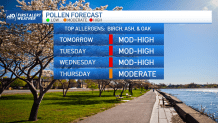
Highs stay in the low 70s Wednesday into Thursday. Although on Thursday a warm front lifts through the northeast and this brings our humidity up again. The humid air sticks around for Friday into Saturday, with dewpoints in the 60s.
Our temps will be in the upper 70s both Friday and Saturday as a low pressure system approaches. This may bring in some summer-like thunderstorms for the start to our holiday weekend.
Then by Sunday our humidity should lower, as a cold front moves through. This front will bring drier air, but not cooler temps by that much. So the holiday weekend looks mainly dry and warm. Stay tuned for updates!