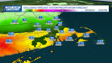
As post-tropical Ophelia continues to weaken, the impulse of moisture and rain bands remain through our Sunday afternoon into Monday.
We’ll keep experiencing scattered showers into Sunday evening, that should spread from tonight into Monday morning. Our morning commute will suffer slower traffic and lower visibility.
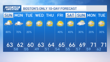
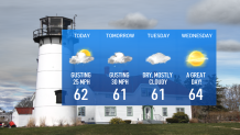
Temperatures will remain below average with cool low 60s dominating through Tuesday. Wind gusts may continue to reach 25 mph inland, up to 30 mph along the coasts.
Get New England news, weather forecasts and entertainment stories to your inbox. Sign up for NECN newsletters.
Drier air will begin to push in on Monday night into Tuesday, keeping only a few clouds around with lowering dew points and clearing skies by Wednesday.
Wednesday will be the pick of the week for many as our skies will be bright, dew points will be comfortable and temperatures will rise into the mid to upper 60s.
The installment of a high pressure system will keep the rain away through Thursday with fantastic weather on tap. Beyond that, the region is expected to experience mild days and cooler nights, highs will stay in the 60s and lows may dip into the 40s with gradually warming temperatures toward the weekend.
Dry and pleasant fall weather is expected through mid-week into the weekend.