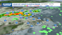
New England continues under cloudy skies, humidity, warmth as well as showers & storms this afternoon. The severe weather threat is lower compared to yesterday.
Some showers and storms are forming in south central Connecticut, and moving into the northeast by the evening. Reaching inside I-495 in the middle of the day.
Click here for the latest weather alerts.
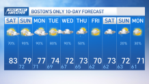
Highs climb to the low and mid-80s but humidity makes it feel near 90 degrees.
Get New England news, weather forecasts and entertainment stories to your inbox. Sign up for NECN newsletters.
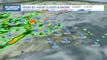
We keep a similar forecast this Sunday with lingering instability, low clouds, patchy fog and afternoon showers/storms. Tomorrow’s rain may have a wider coverage than this afternoon.
Sunday night through Tuesday keeps scattered showers and a few thunderstorms for Monday, with muggy conditions. Tuesday is expected to be drier but still warm and humid.
Meanwhile, more rainfall rolls in from Tuesday night through Thursday due to a robust trough, with potential for severe weather if instability develops.
Beyond Thursday, cooler fall-like temperatures are expected but we’ll keep a close eye on Hurricane Lee as it may impact the region with high surf and riptides.
We’re yet to see if the track allows for the outer bands to bring moisture and rain into our coastal areas as well. Overall, expect unsettled weather with scattered showers and the potential for storms, with the possibility of more heavy rainfall in the middle of the week.