


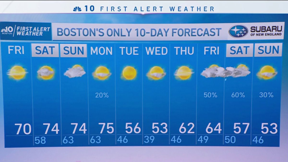
From the NBC10 Boston First Alert Weather Center… Today (Friday): Pockets of AM fog to sun, highs near 70. Overnight Friday Night: Areas of clouds and fog south, otherwise partly cloudy. Lows in the 50s. Saturday and Sunday: Breezy, mild, sun and clouds. Highs in the 70s. Cape Cod Radio Forecast: Today (Friday): Pockets of AM fog and clouds burn off for sun, highs near 70. Overnight Friday Night: Becoming mostly cloudy with areas of dense fog. Lows in the middle 50s. Saturday and Sunday: Morning fog and clouds to a blend of clouds and sun. Breezy from the southwest with peak afternoon gusts up to 30 mph. Highs around 70.
Temps will soar again today. Much of this is a consequence of the mild airmass we’re in, but there’s also a bit of a helping hand from the sun.
Although pretty feeble, the sun does impart some warmth. However, now that we’re in solar winter, defined as the shortest (and eventually coldest) days of the year, we’re incapable of creating Vitamin D at this latitude.
As you might have heard, we’re anything but cold in the days to come. Temperatures are expected to soar straight through Monday, with the Sunday/Monday combo plate appearing as the warmest of the bunch. What’s gnawing at some folks is why it’s so warm this late in the year – especially with the sun angle so low.


Get New England news, weather forecasts and entertainment stories to your inbox. Sign up for NECN newsletters.
The jet stream is to thank (or blame depending on your perspective). It’s a stream of wind in the atmosphere that drives weather systems across the globe. It’s sensitive to large disturbances (i.e., storms) that cause it to dip and rise in certain places. You can liken it to a water balloon; squeeze it in one spot, and other spots bulge. We have a “squeeze” going on in the West that is bringing rain, snow and cold. That squeeze is causing both the Pacific High (east of Hawaii) and the Bermuda High (off the Eastern Seaboard) to bulge or flex. The result is warmth here in the East, lots of it. While this squeezing and bulging is a common occurrence in the jet stream, global warming is playing in the background, and the warmth is both amplified and prolonged.
The warm stretch should set some records this weekend and perhaps into Monday, but as a front comes swinging through Monday night, the toasty temps come to a close. Tuesday we’ll be slammed back to Earth with a resounding thud. Temps fall to seasonable levels, with more cooling into Wednesday.


