
With the threat of severe weather behind us, we’re focused on the tropical threat in the days to come.
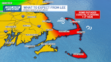
But is that worry overblown? With a track almost 200 miles offshore, we’re certainly not in panic mode. But we’re preparing for at least a close brush with what we could deem a “strong nor’easter”. What exactly does that mean? For many along the coast, this will be a wave-battering-gusty-wind-driven-rain. Elsewhere, this is a raw, rainy, breezy Saturday. The difference between the coastline and essentially “anywhere elsewhere” will be stark.
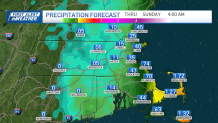
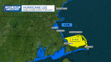
The first wave of rain will arrive predawn on Saturday. The strongest winds will also hit along the coast, but merely gust to 20 to 30 miles per hour just a few miles inland. The Cape and Nantucket will clearly take the brunt of the heavy lifting with this entire storm. It’s here that the gusts may be 50 plus at times through noon on Saturday.
Get New England news, weather forecasts and entertainment stories to your inbox. Sign up for NECN newsletters.
Again, elsewhere, some gusts will be 40 to 45 in Boston and both the North and South Shores, while we “only” gust to 30 elsewhere. The ramp down will be rapid for many, again, except along the Cape and Nantucket, where we could see gusts over 40 miles per hour until the evening. Some power outages and downed trees will be possible on Cape Cod and in isolated spots on the immediate North and South Shores and of course, Cape Ann.
Rain does NOT seem to be a major factor anywhere in this storm. That said, the Cape will see the heaviest amounts, with some spots climbing over 1 to 2 inches. In context, we’ve seen 5 to 10 inch ranges with the thunderstorms this week, so there’s that.
Lee’s girth has grown in the past two days as it sprawls across the Northwest Atlantic. As a result, the wind has piled up a tremendous amount of water under the center of the storm. Storm surge outlooks across the Cape are raising eyebrows for “just a category one storm”. We’re expecting surges in Cape Cod Bay (north facing coast on the Cape) and the outer Cape to climb as much as 2 to 4 feet on Saturday. (This accounts for tidal action.) This may inundate some shore roads and communities during the high tide around noon on Saturday.
Water will be shoved back to sea as the winds turn northwest later on Saturday, and diminish Saturday night.
Weather Stories
Pats game looks great on Sunday and we’ll bounce back from our chilly, raw highs in the low 60s Saturday to the mid-70s on Sunday.
More updates through the day as Lee makes its move.
